
Thursday, Feb 27, 2014 Ely MN
Oh a glorious day. Not to say there weren’t a few bumps-literally-along the way though. Not a lot of pix. our job today was to: stay on the sled, ride the brake as needed, and stay warm. With the camera tucked away, with stops that were brief and of uncertain length, and with temps well below zero, I wasn’t about to unbundle, get cold, and risk losing the dogs just for a picture. But we have a few.
The day began with feeding the dogs and cleaning up poop in the kennel area. This was at 7:30 AM so obviously we were up before that and getting bundled up. They have over 60 running dogs plus a few retired and 6 pups that aren’t ready for anything other than being adorable.
Colin and Greg made breakfast: sausage, oatmeal, hash brown potatoes, granola and yogurt, and “eggs in a basket” (fried eggs cooked inside a cut out slice of toast). We fired up our internal engines with plenty of food before having our inside class on dogsledding.
Colin ran the class while Greg headed down to the kennel to get the teams assembled. We met Susan Schurke, one of the owners, during breakfast and she gave some tips as well as tidbits into the internal operations.
The day was less windy and sunnier than the forecast had led us to expect-a very positive beginning to our journey. I believe the high today was about -5, a nice increase from the -25 during the night. Tonight is supposed to be back to -27.
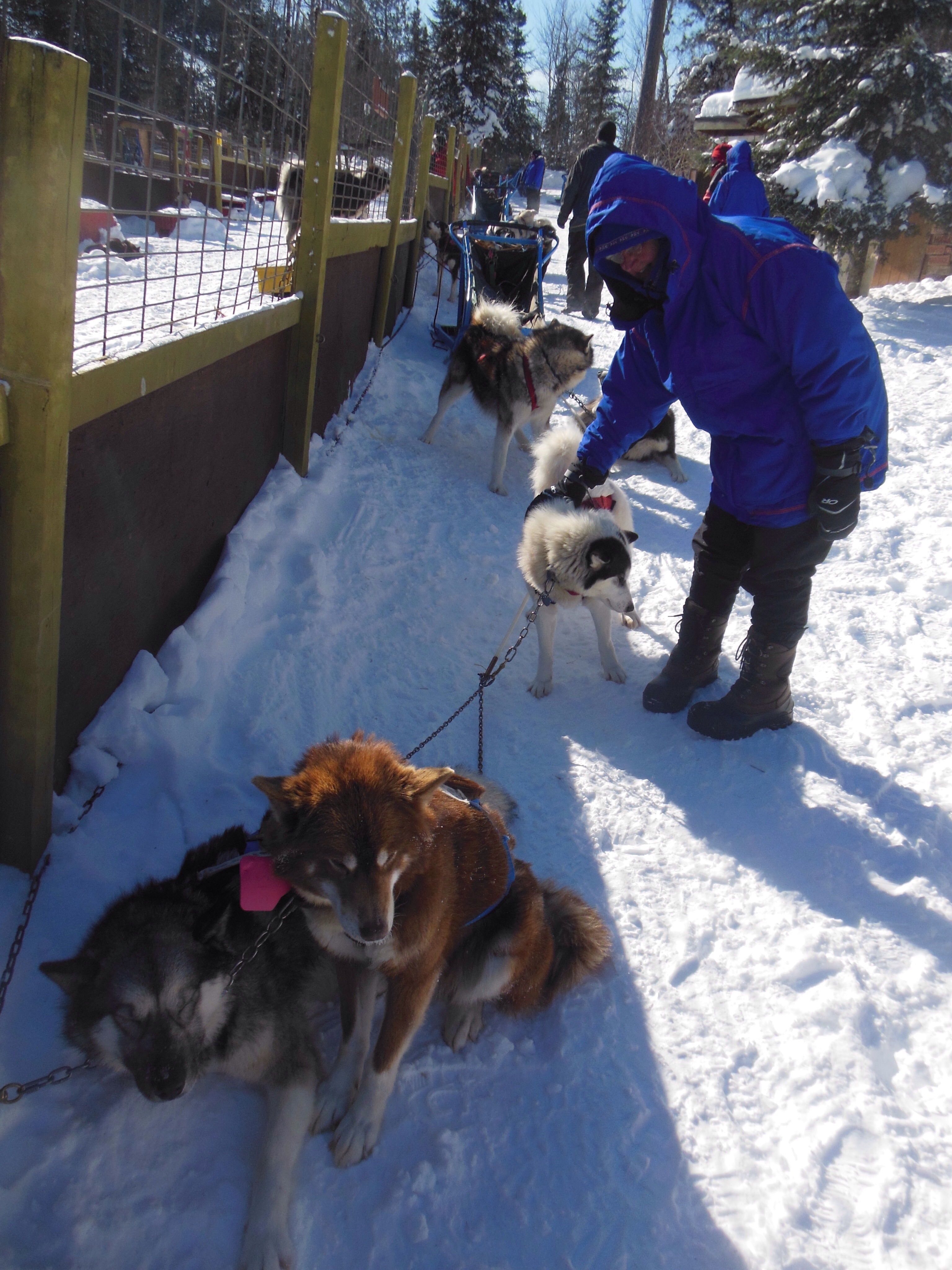
Chris meeting our team Thursday morning.
All of us were able to keep pretty warm, the only cold period was in the early afternoon, maybe around 1 pm, when our 3 teams joined up with 4 other teams and that slowed us down as, of course from my perspective, they were not quite as good as we were. There were numerous moments of waiting until the teams ahead were able to break the trail and keep going.
Last week’s blizzard blew snow over most of the trails and they had to be broken or re-groomed. Today was the first non-windy day so that was part of the challenge. Chris and I were in sled two; sled one, the women from WI, had the joy, challenge, and reward of being the leaders much of the time.
We did not leave the lodge until about 10:30. We were out until after two pm for the first run. We started riding across much of the lake, the wind being noticeable but bearable. We took some trails into the woods. The forest trails are narrower, hilly, and fraught with natural obstacles like trees. Going through the forest must be somewhat liking driving a semi. The cab (dogs) make turns close easily. The trailer (sled with Chris and Ed) don’t turn as tight and sometimes get stuck on, or bump into,tree trunks.
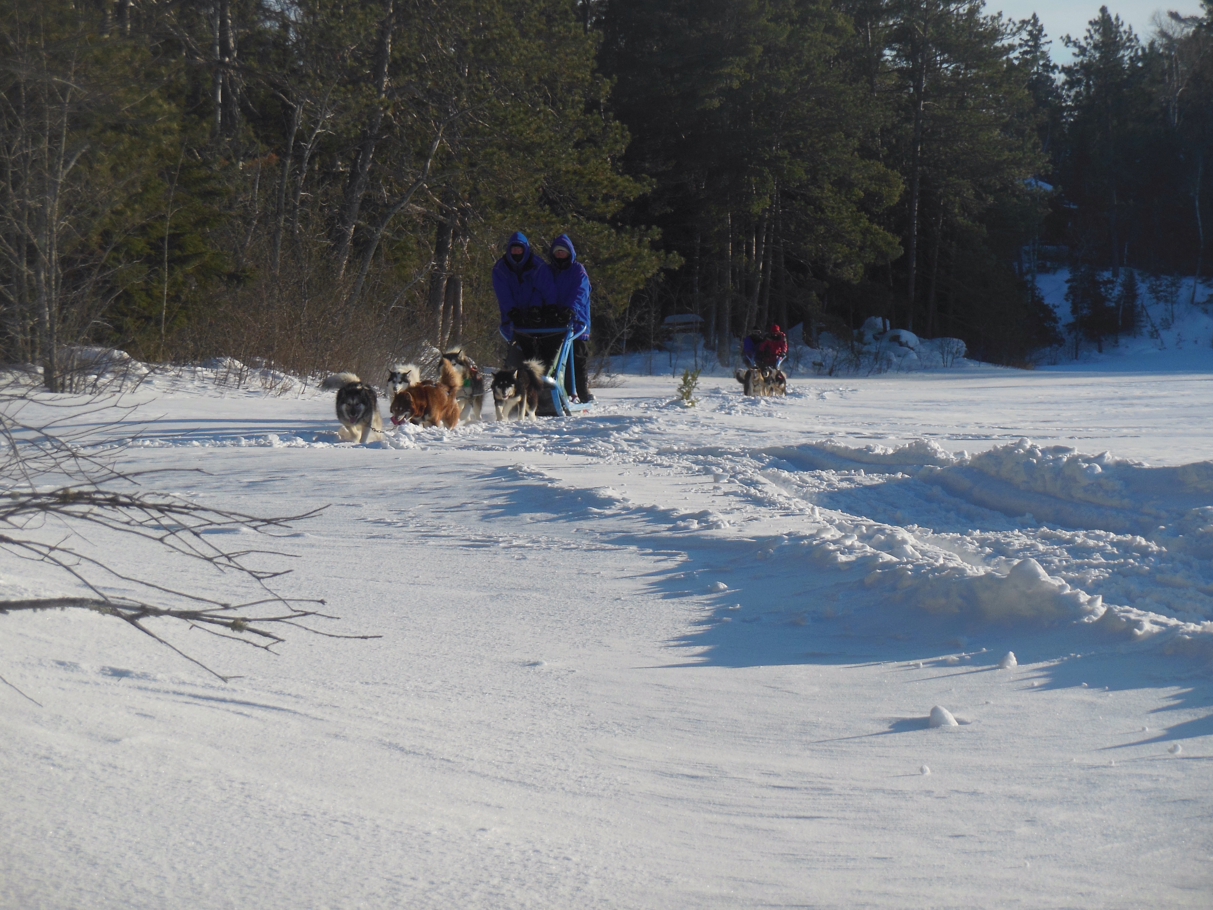
Chris and Ed entering the lake after riding in the woods.
Chris and I each only fell off once. Both times were when we were helping the dogs around tight corners. Luckily each time the other one was still on the sled and able to stop the dogs. Oh yes, dog sledding is not just riding and having a great time.
Well, we did have a great time but there is a lot of exertion involved. You are standing, keeping your balance on running boards, reaching back to step on the brake as needed, helping to push the sled around corners and up hills.
Braking is a challenge. These dogs love to run. You can not run into the team in front. You have to slow them on downgrades. Light braking is fine on low hills. Jumpiing up and down on the brake (a smaller platform behind the running board) to dig into the snow is necessary even as you firmly tell the dogs WHOA!.
When you come to a temporary halt, the dogs are straining to go forward. They are howling to the sky. They are arguing/nipping/biting at their neighbor to establish who is the alpha female or male.

Chris, Ed, Isis Stoney,, Loney, Yukon and Pecan.
The dogs are not perfect. Today Colin led the way most of the time on cross country skis. Sometimes the lead team wanted to go another way, or got slightly off the track and stuck in deep snow, or there was a particularly steep hill or bump that had to be negotiated carefully. Colin usually got to provide assistance.
We came back to our lodge around 2 pm. We shared our lodge with the other four teams for lunch-soup,salad, stromboli, etc. We left for our second ride around 3;45. This time the entire ride was just our three sleds and Colin. Greg got pulled away for other lodge duties. We missed him and kept Colin extremely busy working out tangles and miscreant sled dogs.
We pulled into the kennel before six, unharnessed the dogs and fed them. We were all extremely tired but felt happy, proud and reasonably warm. Before warming up, I started our car. So far, it is okay.
Dinner was chicken, peas and carrots, salad, and wild rice pilaf. Many a toast was raised to our exploits and remembrances of the day. Later Greg showed us some You Tube videos of his previous sled dog teams pulling him at a much faster clip than we attained today.
At 9 pm, we went out to observe the night sky and look for the Northern lights. The stars were numerous and bright. The northern lights were faint to the human eye. Greg’s camera is better than mine and tomorrow I hope to show you his pictures. I doubt that I will get up around midnight to view the northern lights again. They are supposed to be more vivid at that time.
Okay, on to bed and muscle recuperation.
Chris and Ed 10:45 pm


Recent Comments