Posts Tagged With: Heimel Klejbuk travel blog

2023 Trip 8: Flagstaff, South Texas, and Mississippi River: Jan. 10-11

Iowa City, Iowa Jan. 11, 2024


Interstate 80 in eastern Iowa Thursday morning


We will be returning home a day earlier than planned as we travel between two snow events. Both St. Louis and St. Paul have missed, and will be missing, major snowfalls. The geographical area in between is another story as central/northern Iowa gets hammered with snow. On Wednesday, north of St. Louis we started seeing snow on the ground and while roads were clear, there were numerous cars and trucks still in the ditch. Just as we got to Iowa City where we are spending the night, the roads were icy and/or snow covered. On Thursday morning, leaving Iowa City, Interstate 80 was littered with cars and semis, particularly semis, in the ditches. Thursday night to Friday morning another 3-5 inches are predicted so we plan to reach St. Paul this afternoon Thursday, Jan. 11.


Driving through Missouri Wednesday


Yesterday we visited our two last National Park units of this trip. At Ulysses S. Grant National Historic Site we saw their video, had a tour of the home, and visited the excellent museum exhibits. The combination was informative and well done. I had not been sure what to expect here but I would recommend this spot to others to visit. The house, which was called White Haven, was his home for only a short period of time, from 1854-1859.

Grant dropped by the home as a bachelor Army officer stationed in St. Louis to visit the family of a fellow Army officer and West Point grad. There he met Julia Dent, sister of the other officer. White Haven was a plantation with slaves and Julia’s father a strong Southern sympathizer. Grant and Julia fell in love, which survived a four year separation as he had a tour of duty out west, and were then married.

After several years, Grant surrendered his Army commission but had a tough time making a living managing the plantation and other jobs he had to pick up. They moved to Galena Illinois to work for Grant’s father. When the Civil War broke out, he signed up with an Illinois volunteer brigade and moved up the ranks quickly. Hopefully you know about the Civil War, his Presidency, and post Presidency life.

Grant’s views on slavery were at odds with Julia’s father. During Grant’s Presidency, he made a major effort to reunite the country and to implement the promises of equality for all. He had partial success but after his terms ended, the equality efforts ended.

Our next NPS site, our 13th of this trip, was across the Mississippi River again in Illinois. This is a new NPS unit whose site is not yet fully developed. New Philadelphia was the first town site platted and recorded by an African American. However, the railroad bypassed the town in favor of the nearby “white” town of Barry, Illinois and eventually New Philadelphia died away.


Our effort to learn about the site was hampered since some of the displays are in the Barry Public Library-which was closed due to the snowfall the day before. The walking tour with audio displays and an augmented reality app didn’t pan out as the site was covered with snow. The Barry City Hall did help a bit with one brochure, the NPS stamp, and directions to the site-about four miles east of Barry.

We had lunch back in Barry at the only restaurant open downtown. It had two large Trump banners prominently displayed on the rear wall facing the door.

We recrossed the Mississippi River back into Missouri and drove to Iowa City. Today, as mentioned above, we finished this road trip back in Saint Paul. 25 days, 6,464 miles, 13 National Park Service sites, 14 states and we crossed the Mississippi River eight times.

Ed and Chris

Categories: travel | Tags: , , , | 1 Comment

2023 Trip 8: Flagstaff, South Texas, and Mississippi River: Jan. 4

Vicksburg, Mississippi Thursday Jan. 4, 2024

What a fantastic day! It reinforced why we travel as we do.

We left Leesville Louisiana for a one hour drive to Cane River Creole National Historical Park and its 9 AM tour. It was the only tour scheduled for the day so we had to make sure we got there in time.

Oakland Plantation main house

Our Ranger guide had been at this park for 14 years, and was a wealth of knowledge. First off, we had to make sure we knew the difference between Cajun and Creole. As I understand it, Creole is a culture and tradition, while Cajun refers to French people who were forced out of Canada after the French lost the Seven Years War to the British. Many of them landed in the southern portion of the United States. Creole people have ancestry going back to people here before the 1800s whether it be of European settlers, enslaved Africans, or those of mixed heritage, including African, French, Spanish, and Native American influences.

Overseers House
The pigeonnier- the pigeon roost; building one in a highly visible location was a symbol of status and wealth

This historical park preserves and protects two long-standing plantations in the area, Oakland and Magnolia. Sidenote – Magnolia was closed due to inaccessibility because of road construction. The Prud’homme and LeComte families had these two plantations in continuous family ownership since before the 1800s. The historical park is here to demonstrate the full range of history, people, and activities in this region for a 200 year period. It is not intended to be simply a Civil War era plantation.

I have been admonished by multiple sources that I don’t need to re-cap and retell the full 75 minute tour given by our guide this morning. Needless to say, the tour was quite informative, and Chris and I came away with knowledge and appreciation for the area.

After the tour and walking around the site, Chris and I headed out for a three hour drive to Epps, Louisiana, in the northeast corner of the state. Located here is Poverty Point World Heritage Site. (The name comes from the farm where the archaeological site is located, it has nothing to do with the economic state of poverty.) Poverty Point is one of only 20 UNESCO sites in the United States.

Poverty Point- the beige color is the central plaza, the white rings are the ridges homes would have been built on.

Poverty Point is the site of monumental earthworks, the largest constructed in the Americas until Cahokia in Illinois. However, Poverty Point predates Cahokia by over 2000 years. This site preserves over 400 acres of earthworks that were constructed by a hunter gather society starting around 1650 BCE. There is a central plaza of around 43 acres, six semi circular oval ridges totaling about six miles in length that are 4 to 6 feet high where homes were built around the central Plaza, and several earthen mounds. The mounds were constructed probably for ceremonial purposes with the highest mound still at 72 feet.

A view of part of what would have been the central plaza
At the far left and right are what is left of the ridges after plowing by modern farmers, the homes would have been built on these elevated ridges

The earth moving endeavors must’ve been enormous. It is estimated that the earth needed just for the tallest mound would equal 15 1/2 million, 50 pound baskets of soil. And archaeological research indicate this mound was built in just 90 days!

Mound A, the tallest mound

Poverty Point is an active archaeological site today, managed by the Louisiana Department of Parks. This state has an unusually large number of mounds and earthworks, with the first mounds dating back to 5000 BCE. The museum here has displays of jewelry, weapons, cooking devices, etc.

We spent 2 1/2 hours here, with 1/2 of that time on a guided tour on a tram, taking us throughout the site. It is difficult to imagine the site without that overview, but the photos give our best effort to provide you with some perspective. The tour provided fascinating details about the archaeological research and the way the entire site was built over a period of time.

Tonight we are staying in Vicksburg Mississippi. We visited here in 2014, tonight is just lodging, no sightseeing.

Ed and Chris

Categories: travel | Tags: , , , , | Leave a comment

2023 Trip 7: Northwest US: History and Adventure: Oct. 10-11

Mitchell, South Dakota, Oct. 11

Tomorrow, October 12, we should be back at home in Saint Paul. Our blog posts are a little behind so we have a some catching up to do. We were completely out of Internet and cell service at our lodging in the Badlands National Park last night.

Our last posting went up before we went for dinner Monday night in Buffalo Wyoming. You may recall that earlier on this trip we went out for dinner in Mackay, Idaho at a small bar. The people were lining up for darts competition that evening. Monday night, in the saloon at the historic Occidental Hotel in downtown Buffalo, it was trivia night. We did not compete, but the first topic of the solar system would have shown our lack of knowledge on the topic, and we probably would have greatly displeased two relatives.

Tuesday morning we drove to Badlands National Park in South Dakota. The only intermittent stop was at Wall drug in Wall South Dakota. There may be those among you, particularly younger than us, who do not understand the significance of Wall Drug. Wall Drug grew from obscurity to a major destination by the use of plentiful and humorous billboards along the highways in South Dakota. Their initial marketing tool was free ice water. Recognize that this was in the early 1930s when cold water on a hot trip in a slow car across South Dakota to Mount Rushmore and the Black Hills was extremely eye-catching and valuable. They still offer free ice water, and five cent coffee today. There is much more to the story, but I have changed my style to minimize the writing, so look it up yourself.

Badlands National Park in southcentral South Dakota, has wildlife, fossils, and glorious landscapes that show the erosive affect of time, wind, and water. The Badlands get their name from the lack of water and the desire of Native Americans and settlers to avoid it. The topography is American prairies with a wall of eroded rock separating the prairies into a higher and lower natural feature, with the beautiful eroded rock separating the two sections of prairie. We drove the loop road from Wall through the park, which alternates between the higher prairie and the lower prairie.

This is not our first time here, but thought it worthwhile to visit again on the way home. We spent the night in one of the cabins located inside the park. This morning, Wednesday, we did some more walking around before departing for our one more night on the road before reaching Saint Paul.

Ed and Chris, Mitchell SD Oct. 11

Remember—-October 12 is National Farmers Day

Categories: travel | Tags: , , | 1 Comment

2023 Trip 7: Northwest US: History and Adventure: Oct. 6

Old Faithful

Island Park, ID Oct 6

It took us an hour and a half from our hotel in Island Park, Idaho to park and be at the Old Faithful visitor center at Yellowstone National Park. I had forgotten that Island Park is half an hour west of the entrance to Yellowstone. There was a 10 to 15 minute wait to get into the park as the rangers processed the entrance fee for the cars lined up. The fog made for a slower than normal drive, but by the time we reached the Old Faithful area, the skies were blue and the day began its beautiful unfolding.

We walked around Geyser Hill, that area close to Old Faithful that is home to so many small and medium geysers. We made it back to Old Faithful in time for its 10:40 eruption. After a quick lunch, we went on to visit the thermal areas along the Loop Road stretching from Old Faithful to Madison Junction. This includes the Lower Geyser Basin, Firehole Canyon, Midway Geyser Basin, and Fountain Paintpots.

Once again, the rest of the blog is pictorial. I am not going to go into details about calderas, hot spots, magma, etc. Just sit back and enjoy. The hardest part has been done already, winnowing down to the photos to be included.

Ed and Chris, Island Park, Idaho October 6, 2023

Categories: travel | Tags: | 1 Comment

2023 Trip 2: San Francisco: March 2-3

At the ocean at Garrapata State Park

Big Sur, CA March 2

Big Sur is a rugged area of the central coast of California. Multiple state parks offer the opportunity to explore the forest and beaches; except now the 2023 rain storms have closed most of the trails leading to the beach. The Pfeiffer Big Sur park brochure states that the park is still recovering from a 2008 lightning strike fire that burnt 160,000 acres along the Big Sur coast. Our plan is to stick to the forests and coastal cliff tops today, tomorrow we will explore the one place where access to the beach still seems possible.

Hiking to Pfeiffer Falls

An open trail in the forest will take us to Pfeiffer Falls. There is an easy trail that is closed due to the rains so we start out on a smooth path which switches over to the usual rocky steep hike one frequently finds in mountainous forests. I complain as is usual lately. Chris and I reminisce about previous long and/or steep hikes we have taken in the past: the 11 mile, unshady round trip along the Columbia River in Wenatchee-East Wenatchee WA on a hot day, the long, steep hike up Two Sisters Mountain in Rocky Mountain National Park that we never finished, the 600 plus stairs up the Mississippi River bluffs in John Latsch State Park, and others. I am glad we did those when I was younger.

Pfeiffer Falls

Waterfalls are fun to find and watch. Pfeiffer Falls is nice but not overwhelming. We meet a much younger couple and we give them hints about other waterfalls they should seek out. They are shocked that we are married as long as we are; we are shocked that they are dating since she lives in NYC and he lives in New Zealand. In any event, Chris and I make it back to the trailhead safely. Lunch is our first crackers and peanut butter on this trip.

McWay Falls in Julia Pfeiffer Burns State Park

After lunch we drive south along CA 1, the coastal highway, making several stops for ocean views. McWay Falls is our second destination of the day. McWay spills out of the rocks and lands on the beach sand. One is unable to walk down to the beach so our views and pictures are limited. The falls are a popular stop, they are part of Julia Pfeiffer Burns State Park. The first Pfeiffers arrived here in 1869. When a developer wanted to buy land and build homes, Pfeiffer’s son John (who was then the owner) refused and sold the land to the state in 1933 and the land was the beginning of Pfeiffer Big Sur State Park. The CCC built many of the trails and bridges in the park. They also built the lodge, completing it in 1941. Friends of John and Florence Pfeiffer’s daughter Julia donated the land that became Julia Pfeiffer Burns State Park in 1962.

Two large, freshly made sandwiches from the Big Sur Deli and Bakery made up dinner, along with chips and Coke. After picking up the sandwiches, we stopped at a multi-agency visitor center where the staff person helped us figure out how to actually get to the ocean. He was the only one who also knew where to find the Calla lilies blooming in the wild. I had read about these but the directions to find them were vague.

Friday morning the 3rd, we packed up and headed north on CA 1 looking for Garrapata State Park. According to yesterday’s information, the park is basically undeveloped and we had to park on the side of the road just past the bridge construction. We found the parking spot and located the trail leading down to the beach. Finally, ocean waves are at our feet, not hundreds of feet below us. Chris loves ocean waves so she is particularly happy. The beach going north should lead to the trail along the canyon/valley of the Calla lilies.

The canyon is full of running water, our information person yesterday thought the water would have receded by now. In some ways, it was just as well. The walk along the beach had one area with very little space between the cliff and the ocean waves. We did not know if the tide was coming in or out. Walking back to the stairs up the cliff guaranteed we were not stuck on the beach with the tide coming in. An alternate trail to the lilies ran along the top of the cliff, through greenery that was about to explode with blooming flowers. Not the Calla lilies but these will be beautiful in a week or two.

Calla lilies blooming in the wild

We got back to the canyon and found the wild growing lilies. They are abundant in a confined area. A few other couples are taking pictures. What appears to be a formally dressed party of Vietnamese are having a photo shoot. We stay out of their way and take our photos around them. I am pleased we made it here; it is not a riot of color or a huge area but it is something unique we were able to find.

The rest of Friday will be combined with Saturday as we explore Monterey.

Along CA 1 south of Big Sur

Ed and Chris Monterey March 4

Categories: travel | Tags: , , , , , | 1 Comment

2022 Trip 5: Viking Grand European River Cruise: Sept 19

Part of the gate going back to Roman times

In Passau on Sept 20

Regensburg was our touring destination Monday afternoon the 19th. Founded as a Roman camp in 179 AD, and not suffering serious destruction throughout its history, Regensburg has a wealth of varying architectural styles. Even the cobblestones are old, many going back hundreds of years.

The cobblestones on the right are relatively new, on the left are hundreds of years old

Just prior to Regensburg, we ended our time on the Rhine Main Danube canal and were now strictly on the Danube River. Our ship docked on the waterfront and we walked to the old city. As we were frequently told, ‘Blue Danube’ could easily refer to the idea of blue meaning drunk in German or from the reflection of the blue sky on a clear summer day. The water itself looks more greenish.

The city is another university town and our walking tour went past portions of the city which were lively and some more deserted. I thought the cathedral here, St. Peter’s, was one of the more attractive ones, Many of these cathedrals are now owned by the state as maintenance costs are exorbitant. It seems that you will always find scaffolding around them since repairs take so long that by the time they finished it is time to start again.

There was no opportunity to visit museums since Monday is the normal day for all of them to be closed. Instead we did some more walking and then returned to the ship for another excellent meal.

At the end of the day the sun came out and the temperature hit the mid 50s

Ed and Chris

September 20,2022

In Passau

Categories: travel | Tags: , | 1 Comment

2022 Trip 1: Searching for our 300th National Park Service Site: April 16-17–We Hit 300!

Salisbury, MD April 17

Our two and a half hour drive to Dover DE was much more relaxing than the Friday drive. There were fewer cars early in the morning so less congestion. Still plenty of high speed dragster type speeders to be seen though.

Our NPS destination was Dover Green and the Old State House, one of the sites constituting the First State National Historical Park. Delaware has an interesting history. The Dutch and the Swedes were two major immigrant groups that set up colonies in what is now Delaware. From 1638 to 1655, Sweden had a colony centered around present day Wilmington DE. The Dutch established a colony at Lewes DE and took over the Swede’s colony in 1655. The English kicked out the Dutch in 1664 and through a land grant gave Delaware’s three counties to William Penn and Pennsylvania. The Delaware people resented the Quaker control from Pennsylvania and depending on who you believe, either broke away or were allowed to leave Pennsylvania. (If you are looking for an interesting history to read, try Russell Shorto’s “The Island at the Center of the World”. The book tells the history of the Dutch colony of New York and how the Dutch customs had a lasting influence on America.)

Delaware’s claim to being the First State is rooted in the December 7, 1787 vote by the 30 delegates elected to a state convention to consider ratification of the U.S. Constitution. The vote to ratify was taken at the Golden Fleece Tavern on the Dover Green where they were meeting. Delaware was only one of three states where the vote to approve was unanimous. Delaware’s vote to approve beat Pennsylvania by five days.

We walked around The Green, established in 1717 according to standards set by William Penn; had a tour of the Old State House; and walked by the site of the Golden Fleece. The Golden Fleece Tavern was demolished around 1830, evidently historic preservation laws did not exist then. One interesting factoid. The Old State House has two replica staves, poles with a wooden triangle at the top, one side red and one side white. When a decision was made by a court in the olden days, the staves were placed outside. If the white side was showing, the defendant was innocent. If red, guilty.

Hoping to not repeat the bust of viewing very few big birds at Mason Neck and Occoquan Bay wildlife refuges, we stopped at Bombay Hook National Wildlife Refuge. This refuge was established in 1937 and has 16,000 acres along the flyway for the Atlantic coast. The name comes from a poor translation of the Dutch “Bompies Hoeck” or little tree point. The Civilian Conservation Corps built dikes, cut timber, ran ditches for mosquito control, and generally built the first level of improvements between 1938 and 1942. Our luck improved, heron, egret and various and unidentified waterfowl were present.

Our final stop of the day was another plantation owned by a wealthy founding father. John Dickinson was a delegate to the Continental Congress, primary author of the Articles of Incorporation, and drafter and signer of the U.S. Constitution. He had homes in Wilmington and Philadelphia and his plantation in Delaware. He served in both PA and DE legislatures depending on his residency at the time. His signing of the U.S. Constitution came as a delegate from Delaware. He authored numerous tracts that helped solidify support for the Union although he abstained from signing the Declaration of Independence. He was one of the moderates who was not sure if independence’s time had come. After the Declaration of Independence passed, he joined his local PA militia and reached the rank of Brigadier General.

When we toured the house, the front door was facing an empty field. The tour guide explained that in Dickinson’s day, the St. Jones River was just outside the house. Through the passage of time, the river changed its course and is now off in the distance. The river access was important, it was the means of transport to move the crops to market. Without having taken the tour, we would have been left wondering about the placement of the house.

John Dickinson always brought a sense of pride for us. We lived for several decades in Carlisle PA where Dickinson College is located. Although Dickinson was founded by Benjamin Rush, a signer of the Declaration of Independence, he had it named after John Dickinson, a good friend of his.

For three nights we are staying at a Hampton Inn located in Salisbury MD. It offers a central location allowing us to easily journey to our next planned stops.

Today started at the Harriet Tubman Underground Railroad National Historical Park-OUR 300TH National Park Service Site. A moving story of one amazing woman. Born into slavery; watched her sisters sold away and never saw them again; married to a free Black man but left him at age 27 to escape herself being sold to another owner; personally helped 70 enslaved people reach freedom through 13 return trips over 10 years including her parents and siblings while advising hundreds of other enslaved people; served the Union Army as a nurse and spy; worked for women’s suffrage; and founded a home for the elderly and disadvantaged. Whew! And what have you, and I, done to win or protect civil rights?

Even more striking to me was not her many accomplishments against much adversity but the realization once again that enslaved people just had no rights. How horrendous to watch your children beaten or sold away never to be seen again. You had no rights, no courts, no appeal to social media, no internet funding for your problems, not even the right to strike the hand of the person doing this to you.

Our next stop was the Blackwater National Wildlife Refuge. Here once again, in an area of natural beauty, we find man’s inhumanity to man. In 1642 Maryland Governor Cecil Calvert declared war against the Nanticoke Indian tribe. For the next 26 years, it was legal for any Englishman to shoot any Indian who got in his way.

Today most of the Nanticoke are long gone but this area along the Chesapeake Bay houses a wonderful visitor center to go with its 30,000 acres of wetlands, tidal marshes, crop lands and forests. Most wintering species of birds have left the area but we spotted great blue heron, great egrets, osprey, and the biggest thrill, a red eastern screech owl in a tree cavity. Okay, another person pointed out the owl to us but still we saw it. It almost looks like a small cat in a tree.

We spent the rest of the afternoon traveling back roads to visit locations along the Harriet Tubman Underground Railroad Byway. We saw where she is believed to have been born; the general store where she was hit by a two pound weight tossed by a white man at a fleeing slave; a church which housed a free Black preacher who helped Harriet Tubman escape (he served five years in prison for owning a forbidden copy of Harriet Beecher Stowe’s novel ”Uncle Tom’s Cabin); a grist mill functioning as a networking site for free and enslaved people, and a river location on the Underground Railroad.

On the right, the red eastern screech owl, on the left the tree cavity it was sitting in at the end of the diagonal tree trunk

Ed and Chris, Salisbury MD April 17

Yes, 300 National Park Service sites!!

Categories: travel | Tags: , , , , , , , , , , | Leave a comment

Back on the road again-Finally #3

Itasca State Park, MN May 13, 2021

We have truly lucked out with the weather. Most of the day was sunny with a temperature in the 60s. It became a little cloudy in the afternoon with about a 10 minute brief shower after 4 PM. All of our walks today were within Itasca State Park. The park is over 32,000 acres in size with over 100 lakes. There is plenty of area to experience. We chose a variety of trails today. The first trail is part of the hiking club trail system within Minnesota state parks.

Previous readers of this blog will recall that in our travels around Minnesota, we obtain a stamp from each park to verify we have visited the park. We are currently in our second time through the list of state parks and we have been to 27 of the 75 state parks and recreation areas. Each park has had signs indicating a trail with the words Hiking Club. In our first go around, we were unaware of the “Hiking Club” and assumed it was a membership type group.

Later we discovered the Hiking Club is simply one recommended trail at each park to hike. There is a separate Hiking Club booklet where you enter the date you made the hike and you are rewarded with patches, etc. Well, the patches are not our motivation but since we plan to visit each park, we decided this time to walk the Hiking Club trail as we visit each park. To make sure one does not cheat, there is a password associated with each hike. Of course, you find the password at about the halfway mark of each designated trail. As we take the hike, Chris and I have been guessing what the password might be. It is usually related in some way to the park or the trail. Today’s password was Omushkos.

Omushkos is the Ojibwe word for Elk Lake which was the Ojibwe name for Lake Itasca. Itasca was given as its new name by Henry Schoolcraft who “discovered” the lake and named it for the Latin words for truth (veritas ITAS) and head (caput CA ). Of course, Schoolcraft only “discovered” the lake because a Native American leader named Ozaawindib guided him here.

The trail today for the Hiking Club was 3.5 miles and traversed the Deer Park path, a crossover path, and the Ozaawindib path. In this part of Minnesota, glaciers did not leave the flat agricultural lands one finds to the south and west. Instead there is a series of hills, valleys, and indentations that created a hike of ascents and descents over terrain that varies between sand and rocks and tree roots.

Luckily, we were able to be delighted by the vistas. Tall pines, new growth aspen and birch, blue lakes and skies, marshes and lovely wildflowers. The wind was loud but seemed to only blow at the level of the tree tops. We could hear it but rarely felt it. On the trails we took, the wildflowers were usually small and just starting to have fully emerged. White, yellow and blue blooms were abundant but no pink or red were to be seen.

After lunch of tuna salad and crackers back at our cabin, we tackled several smaller hikes located along the Wilderness Drive. Wilderness Drive makes a circle through part of the park and road can be used by cars and bikes. Each of the shorter hikes has a theme: trees blown down by wind, areas replanted by the CCC, etc. Frankly, the Hiking Club trail was more interesting and delightful; even if more tiring.

For dinner we ate at McDonalds as we returned to Park Rapids to upload photos. Just because I bought more data time did not mean the Internet speed out here at the park increased.

Tomorrow we return home with an intermediate stop at Charles Lindbergh State Park in Little Falls, MN. Our blog post from 2014 Trip Five, Aug. 14 discussed the Lindbergh home historic site. The state park is separate.

Ed Heimel, Chris Klejbuk May 13, 2021

Categories: travel | Tags: , , , , | Leave a comment

2019 Trip 6: Voyageurs: Oct. 9-14

International Falls MN. Tuesday October 15

Inside of the Rainy Lake Visitor Center at Voyageurs National Park

We have completed our second four day weekend volunteering at Voyageurs National Park along the border between Minnesota and Ontario. The weather has been less than spectacular, primarily gray, windy, and rainy with some snow showers along with periodic patches of blue sky. Visitors have been positive however, most still hoping to go camping, hiking, or canoeing. For those visitors who are interested, we have been able to offer them some camping options they can reach by car.

First arrival

October 5

October 8

Now

In the two weeks we have been here, the deciduous trees have portrayed the complete cycle of green to yellow/orange/red to falling off the tree. There are still locations of beautiful color but are much fewer and even then, usually only a portion of the tree. The rain and wind have played out their role in the cycle of life; I expect soon the green of the conifers will be mixing with brown tree trunks and blue waters. The forecast for the next ten days does not call for any appreciable snow. From pictures and past experience though, the white of the frozen lakes and snow covered ground offers a new beauty option to look forward to.

Last Wednesday, our final day of our three days off, we accepted an offer from the couple we met at the Great Decisions meeting. They took us on a boat ride around the some of the islands in Rainy Lake outside of the national park. If you were to look at a map, you would note that Voyageurs National Park only includes a portion of Rainy Lake. The lake extends west to International Falls and includes numerous privately owned islands. The lake also extends north into Ontario where the landscape includes even more lakes and waterways than Minnesota.

Taking off for the boat ride

Along the way

A boys camp on an island

Approaching our hosts island

Our boat trip provided us not only with splendid views of the lake and islands but our hosts’ personal perspective of the resort based history of this area. Resorts were started here in the early 1900s. The first resorts did not have electricity or indoor plumbing but visitors came here from all over for the scenery, relaxation, boating, and fishing. As time marched on, indoor plumbing and electricity made it to the islands. Island habitation rotated between resorts, camps and private residences.

Some island inhabitants had a second land based home; others lived on the islands year round. Spring and fall would have short periods of time between open water and solidly frozen ice when one waited out the change or used a variety of transportation options to reach shore. The boat ride truly demonstrated that the love of place rang deep in the inhabitants of the Minnesota north woods and lakes.

View towards Kabetogama Peninsula from Rainy Lake Visitor Center at Voyageurs National Park

Ed and Chris Tuesday, Oct. 15

Categories: road trip, travel | Tags: | Leave a comment

2019 Trip 5: Alaska: Sept. 3

Safety briefing number two at the runway by our plane

Homer AK. Tuesday September 3

Another WOW experience but maybe not for the reasons you might expect. Today was airplane vistas, bears and mud. The bears we were “hunting’ were in Katmai National Park, along the coast near Mt. Douglas. This is their natural environment and although we had planes and knew where they tended to congregate, there was no guarantee. Our locations were scattered; not Brooks Camp, a spot in Katmai National Park where bears line up to catch salmon and the Park Service had to install a boardwalk for people to see the bears without getting too close to them.

Our time to arrive at the hangar and begin the prep was 10 AM. Time is based on tides (we need low tide to land and take-off at Katmai), weather, and bear spotting. We arrived at the hangar early and were the second ones there. First task is to get fitted for waders, crotch high rubber boots with a strap at the top that goes through your belt or belt loops to make sure the waders stay up. Chris and I ended up selecting one size smaller than the initial estimate based on our shoe size; it seemed a better fit. (Remember for later.) You do not wear your shoes, just socks, inside the waders. I noticed our guide/naturalist/pilot wore a different type; waders with socks attached and lace-up boots over the waders.

Today Alaska Bear Adventures used three planes. Each was a Cessna 206, a plane highly popular and long in production. It holds six people, the pilot and five passengers. Our plane had us plus another Minnesota couple (from Eagan and he worked at WestLaw) and a local woman who was a firefighter with a day off from working the wildfires. We formed a jovial group.

View of Homer Spit

The flight from Homer to Katmai takes about an hour. It is over water, we had on personal flotation devices. ABA gives you two safety talks, in the hanger area and at the plane. Chris and I had the two middle seats, each with a window. You are given ear plugs to use if desired, small plane engines can be noisy. Take-off was no worse than a normal take-off with a jet, just that everything is so close outside your window.

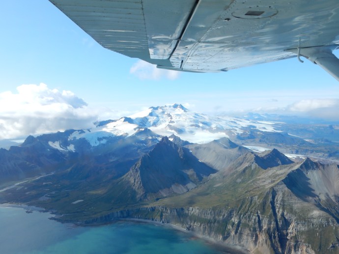
Flying to Katmai National Park from Homer

The views are amazing. We had never flown on small planes before, just the helicopter ride in Kauai, Hawaii six years ago. Frankly the plane ride was a big reason to take the trip, seeing bears was just a bonus. Chris had worried about it for weeks, even to the point of making sure she did not eat too much and gain weight. Well in advance of the trip, you have to weigh yourself at home with the clothes you are likely to be wearing. You can not be more than ten pounds more at weigh in than the weight you told them in advance. The night before the flight I found myself getting nervous about the flight over water and the bears for no apparent reason.

Our circular rainbow

The landing strip on the beach, our planes, and walking back to the planes after bear number three

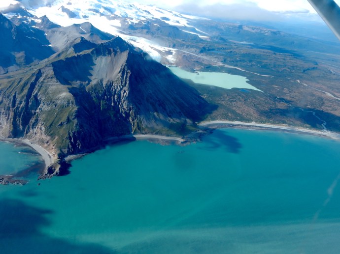
Out the window we saw the Homer Spit with a cruise ship in port; fishing boats in the bay, Seldovia, mountains, glaciers, and islands. I saw my first circular rainbow down below the plane. When the conditions were right, the outline of the plane was inside the rainbow! Our landing spot was on the coast near Mt. Douglas, a volcano, between high tide line and low tide line. It had a lot of small rocks, quite bumpy. And Chris loved it; this from a woman who used to close her eyes and say a prayer at every commercial plane take-off and landing.

Beach view of Mount Douglas after landing at Katmai National Park

Katmai is huge, we were touching only a tiny portion of it. Katmai is the fourth largest national park, about the size of Connecticut. Katmai was initially a national monument formed to protect the area around a volcano. In 1912, severe earthquakes rocked the area for a week before Novarupta erupted with a force over ten times stronger than Mt. St. Helens in 1980. It is estimated that only two eruptions in modern times displaced more volcanic matter than Novarupta (Greece’s Santorini in 1500 BCE and Indonesia’s Mount Tambora in 1815). The isolation of the region prevented major loss of life. It is estimated that if the eruption had occurred in Manhattan, there would have been zero survivors, ash in Philadelphia would have been over a foot deep, and the sound would have been heard in Chicago. The eruption left a valley with thousands of smoke vents; named Valley of 10,000 Smokes.

Walking to find bears

Bear number 1

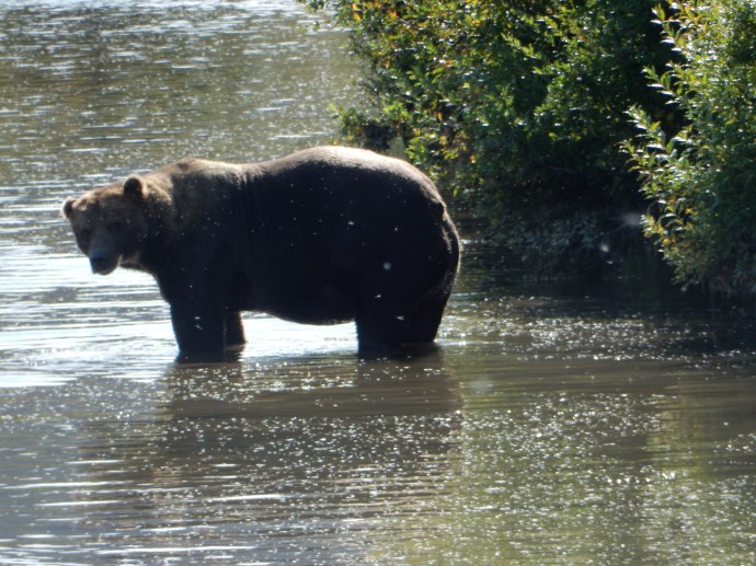
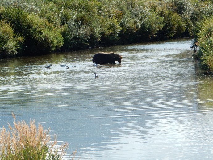
We were here to see bears though. Off on our hunt we went. Successfully. We saw three bears. The first was after a hike through the grasses to a creek feeding into Douglas River. We passed two indentations dug out along the creek where a bear had carved out a napping spot. The path we followed was one used by bears also. We maintained a safe distance of 50 yards or so; the bear acknowledged we were there but did not interest him. The guide estimated this one was about 900 pounds. Coastal brown bears tend to get larger than most in Alaska (1200 is not unusual here) due to the abundance of good food sources on a year around basis.

Salmon were abundant in the stream, many having already spawned and just starting their death spiral. These do not interest the bear. Given the abundance, the bears here can be choosy looking for fresh salmon who have yet to spawn. We spent about 20 minutes just watching the bear as it waded along the stream, catching fish, and eating.

To reach our next bear was a longer hike. Most of the travel was beside a creek bed where we walked along the creek on top of rocks. Here was where the lack of any real support in the waders became evident. One could feel the outline of each rock you stepped on. After a while the process was less than exciting. Some of the time we walked in or across the creek. The waders were essential. The water was frequently knee high. The creek bottom alternated between rocks and sand, that glacier flour we have commented on before which gives the unique coloring to glacial waters. One tried to avoid stepping on dead salmon. One woman found her waders had a hole so that at a certain depth in the creek some water came into the bottom of her wader.

Bear and human tracks across the mud

At other times we walked across the land left muddy by the changing tide levels. Frequently we passed the tracks of bears; large paw prints heading in the general direction we were traveling. It was curious to compare their prints with that of the six of us marching through the muddy plains.

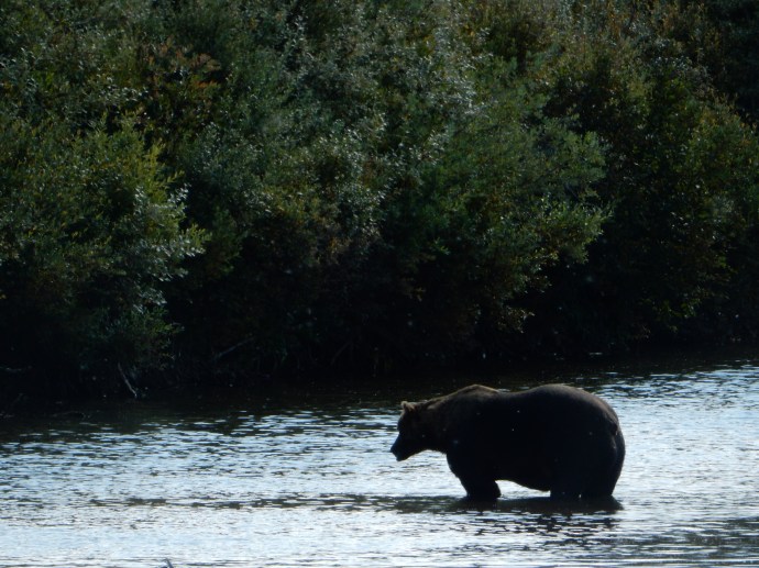
Bear number two that led to our adventure

The two other groups had taken off from the airport first, landed first, and then were the lead hikers. We were several minutes behind them. On the hunt for a second bear, the two of them followed a path and then our group started to veer away from theirs. Our leader had seen a bear in the distance. As we approached the bear, it noticed us and decided to take a hike. It walked behind a ridge and out of our view.

This left our group with the need to catch up with the first two groups. We, led by our naturalist/guide/pilot, cut across the muddy flats. Suddenly the muddy flats were turning into a quicksandish type of goo. One could not easily move forward without taking small steps, pulling up on your waders as you tried to move forward. Each slow step meant you were standing on your other foot for a longer period of time, allowing the pressure to push that foot further into the goo. You could hear the boots go “schlupp, schlupp” as they emerged from the suction grip of the goo. If we had been in the bigger boots, I fear they would have been pulled off despite the straps, the suction power of the goo was that strong. The phrase “stuck in the mud” has a much more personal feeling now.

After our mud adventure. Smiling? It was pretty scary.

Then in attempting to pull a foot out of the goo, one of the group went down. Getting back up is not easy. Then both Chris and I went down, getting goo over much of us. It took our guide with his more firmly attached boots to help each of us over to a safer location about 100 yards away. Each member of our group either fell or was stuck, needing assistance in getting to more solid ground. As one member stated, if a bear had come along then, we would have been a tasty morsel. As it was, all ended well. Clothes needed to be washed down and then laundered. We had a bonding experience. Long-lasting memories were made with a humorous tale to recount.
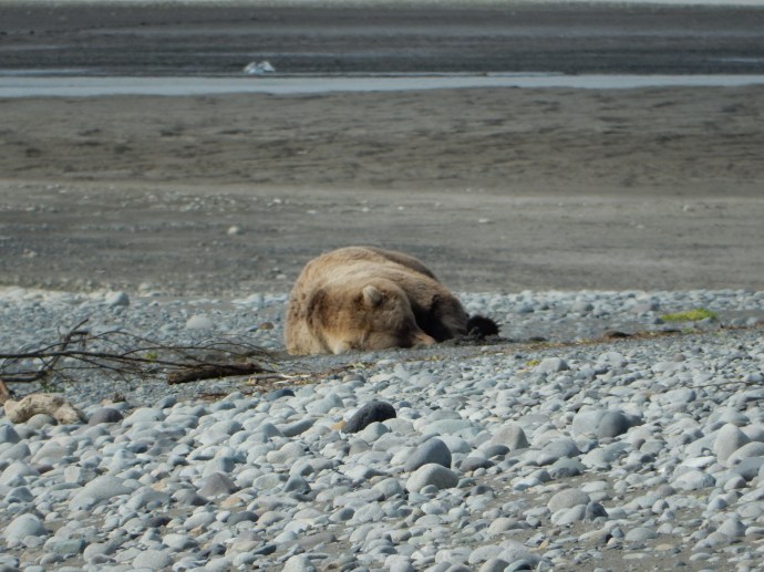
Bear number three

The two other groups had found a third bear and we joined them. This bear was lying down, trying to nap. our appearance caused it to raise its head periodically before it went back to attempting to nap. Despite our waiting and watching for the bear to do something more exciting, it just laid there. Eventually we headed back to the planes, only then realizing that we had come a long distance and the hike to the plane took longer than I thought it would. During the “goo” time I had stated I would no longer think poorly of walking on the stones and rocks. However, the long walk back along the rocky shore made we almost wish for the soft sand and mud.

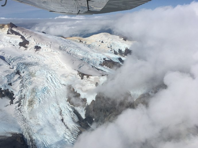
Flying back from Katmai

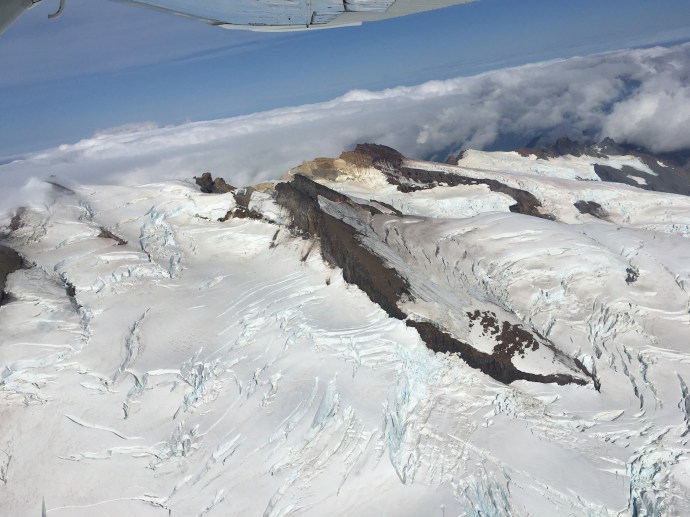
The flight home was a gem. Our pilot took us up and around Mount Douglas. Mount Douglas is 7,000 feet in elevation, is a stratovolcano with a small crater lake near the top, and active fumaroles. Gorgeous views.

Flying home from Katmai

Kenai Mountains flying back to Homer

The trip back over Cook Inlet was uneventful but the views of the mountains and glaciers across from Homer (Kenai Mountains, town of Seldovia, Kachemak Bay and Kachemak Bay State Park, Wosnesenski Glacier, etc.) were another treat.

All in all, the day was 7.5 hours of fun and excitement. The vistas were great, Chris is even willing to try flying in a small plane again.

The view Ed had of Kachemak Bay and Kenai Mountains from the kitchen of our AirBnB while working on the blog

Ed and Chris. September 4. 4 PM

Categories: road trip, travel | Tags: , , , , | Leave a comment

Blog at WordPress.com.