St. Paul MN May 22, 2019

Museum of the Moon at the Bell Museum St. Paul
Almost all of our blog posts are travel adventures; trips away from the Cities, whether elsewhere in Minnesota or more likely, around the U.S. or Canada. In the past two weeks however, we experienced a diverse set of activities that seemed worthy of mention. The activities reflected the non-standard activities available to a person in the Cities, not just the museums and historical locations.

The Noecker group marching
Our tale starts on Saturday May 4 for the 34th annual Cinco de Mayo parade on the West Side of St. Paul. This year, we marched with a group sponsored by our St. Paul Councilmember, Rebecca Noecker. As is our style, we arrived plenty early and had chatting time with other parade marchers and volunteers. The West Side of St. Paul is actually south of the Mississippi River since the river here takes a bend and changes from a north-south orientation to an east-west orientation for about eight miles. Thus, here the city is considered to be on the west bank of the Mississippi. It is the only section of St. Paul located on the south or west shore. Historically, this area was Dakota land and as treaties removed the Dakota from their homeland, French-Canadian, German and Irish immigrants settled here. (My German father’s house was on the West Side.) Later Eastern Europeans moved in and then it became home to a thriving Mexican immigrant community, which it still is today.

Cinco de Mayo parade St. Paul MN
The Cinco de Mayo festival and parade here is reported to be one of the ten largest in the U.S. But as a parade participant, we saw more of the crowd and less of the parade. The day was pleasant and the crowd numerous and relaxed. Families with children and grand-parents composed the large majority of the people lining the street.

The crowds at the Mayday Parade Minneapolis
On Sunday, May 5, we traveled compass-west and river-north to Minneapolis for the 45th annual MayDay Parade, Ceremony, and Festival sponsored by In the Heart of the Beast Puppet and Mask Theatre. Boy, this was the time to really see diversity in Minneapolis. The parade runs down Bloomington Avenue to Powderhorn Park where festivities continue all afternoon. Knowing there would be an even bigger crowd for this parade, we arrived with plenty of time to people watch. We were the unusual ones; we did not have a dog, did not ride a bike, did not color our hair, did not have a tattoo, did not have a child present, did not wear clothes with a message, etc. Once again the crowd was polite; maybe more boisterous and jolly, but still uneventful. The parade is self-managed, no police cars leading the way. In fact, no motorized vehicles are allowed in the parade, unlike Cinco de Mayo which has a large crop of public organization vehicles. The crowd lined the sidewalks and curb area, leaving a small walkway for people to get through.

Mayday Parade

Mayday Parade

Mayday Parade Minneapolis

Mayday Parade Minneapolis

Mayday Parade
This year’s theme was Beloved Community revolving round reconciliation and respecting our earth. Community groups are encouraged to participate with their own display that ties into the overall theme. After the parade, there is a community festival at Powderhorn Park.

Como Park Conservatory

Inside the greenhouses at Como Park Conservatory
Thursday, May 9 brought us back to a familiar site but with a different focus. We have visited Como Park, Zoo, and Conservatory frequently. Today, though, we had a catered breakfast in one of the gardens followed by a behind the scenes tour of the greenhouses. The Conservatory grows many of its plants and will rotate specimens during the year. Rotating exhibits are designed by horticulturists and other Como staff. In the off-season for that plant, many plants are stored in the greenhouses at the appropriate off-season temperature.

Inside the greenhouses at Como Park Conservatory
The greenhouses are awash in colors, row upon row of plants in various stages of their growth cycle. Drip irrigation systems contrast with overhead irrigation. Large tubs of water host the first growth of the large pond Victoria Water Lilies that will appear outside Como come late July. Winter blooming plants are kept chilled until they are ready to pop. The chilling goes so far that the combination of cold and moisture sometimes creates a few flakes of snow. Would this not be a great place for someone to volunteer if they are into gardening?
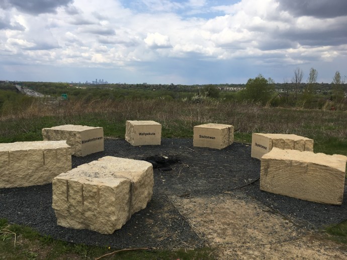
Saturday May 11 we switched gears again. For 8 hours we saw and heard about the history and significance of several places of cultural, religious and historical importance to the indigenous peoples who lived here prior to European immigration. While the Dakota people were not the only indigenous people to live here, they were the ones present when Americans started moving here from the Eastern states in the 1800s. Fur trappers preceded the settlers and while the fur trappers did not take the Dakota land, their pattern of trapping the native beaver to near extinction created long-term destruction of natural habitat that still persists today. The treaties signed by the U.S. were never sufficient in the eyes of the new settlers. Treaty violations and treaty non-compliance by the U.S. government drove the Dakota in 1862 to declare war on the settlers, killing hundreds. The state raised an army and defeated the Dakota. After the war, 38 Dakota men were hung in the largest mass hanging in U.S. history. The remaining Dakota were shipped out of state after forced marches and winter imprisonment in camps. This fulfilled the demand of then-Governor Ramsey of Minnesota that, “the Sioux (Dakota-note Ed) Indians of Minnesota must be exterminated or driven forever beyond the borders of the state.”

Mounds Park

Wakan Tipi
During the daylong event, we listened to speakers and visited several sites. Mounds Park (Kaposia) is the site of six remaining burial and spiritual mounds; others have been excavated and bulldozed with the relics sold to museums. Wakan Tipi or Bruce Vento Nature Sanctuary is located below the bluffs of Mounds Park. The site remains a Dakota sacred site today even after the railroads bulldozed the front portion of the cliff entrance to the cave for more railroad tracks. At Fort Selling historic site and at the overlook to the confluence of the Minnesota and Mississippi Rivers, we heard how the Dakota used to converge on this spot for mothers to give birth. Unfortunately, this spot was chosen by the U.S. soldiers for a fort and was used as the internment camp for Dakota people during the winter after the Dakota War of 1862. (The actual internment site is located in Fort Snelling State Park on the river below the Fort and the park was closed due to high water.)
Looking from Pilot Knob towards downtown Minneapolis in the distance
Finally we stopped at Pilot Knob. To the Dakota the prominent hill was known as Oheyawahi, or “a hill much visited.” It was here that the Dakota buried their dead and Dakota villages dotted the river below during the early 1800s. The hill remains a sacred place to the Shakopee Mdewakanton Dakota. All in all, it was an awakening experience to learn the beliefs of the Dakota people who preceded us here and who still fight for respect and treaty rights.
Wednesday night, May 15, the Voyageur National Park Association hosted an event in Minneapolis. (You will read more about Voyageurs on this blog come October.) It was held at Open Book’s auditorium and about 60 people showed up. The speaker was Ben Goldfarb, author of the award-winning book “Eager, the Surprising, Secret Lives of Beavers and Why They Matter”. Ben is an environmentalist journalist, editor, and beaver believer. We were surprised; the author was an excellent speaker and provided in an interesting way new information about beavers. There is a movement in the country to allow beaver freer rein to build their dams; improved water retention, fishing, and decreased flooding are likely to result if we can resist our emphasis on man-made answers to the problems we have created in our environment.

From the beaver diorama at the Bell Museum
Beaver pelt were the only export early American settlers had to pay for their English made goods. Beaver hunting fueled the economy, drove westward expansion and settler anger at British limits on expansion, and by the late 1800s had practically exterminated beavers in North America. This over hunting resulted in topography that is drier, has less animals, and is more barren then pre-1700s. The impact is still felt today and the American instinct to build man-made structures to replace what nature does on its own continues to haunt us. We bought a copy of the book and suggested to the Bell Museum store that they stock it.
Just one interesting tidbit: The Catholic Church, in 17th century Quebec, after discussions with theologians in France, declared beaver a fish since even though a mammal, it swims. Therefore, Catholics could eat the red meat of beaver on Friday during Lent without a guilty conscience.
Last weekend, May 18-19, was the inaugural Doors Open Minneapolis event. 115 buildings throw open their doors and invite the public to visit and take a peek behind doors normally closed. Venues included historic buildings re-used for hotels and offices, public works locations like a hydro plant or recycling facility, churches normally open only to their members, public yet private areas like the Federal Reserve or Post Office.
St. Anthony Falls Lock and Dam was one of the 115 venues open to the public. Each venue had its open staff or volunteers welcoming guests. In addition, Doors Open planned to have two volunteers at each of the 115 venues, working in two shifts of four hours each. Doors Open needed 900 volunteers. I do not know the final result, but it seemed like they came close to reaching their goal.
On Saturday, I was a volunteer for the National Park Service and Army Corps of Engineers (not a volunteer for Doors Open) at the St. Anthony Lock and Dam. We had over 400 visitors between 10 and 2, on a blustery dreary day.

Sample artwork at the Intercontinental Hotel MSP AIrport
On Sunday, Chris and I were volunteers for the Doors Open program. Our shift was at the Intercontinental Hotel at MSP airport. It opened in July of 2018 and has a very nice collection of art work. The hotel manager gave us a tour, visitors received a hand-out for a self-guided tour. Our gig as Doors Open volunteers required us to greet visitors pleasantly, answer questions, guide them as to the best route and provide them with complimentary parking garage passes. During the other half of the day, we visited two sites.

Danish American Center
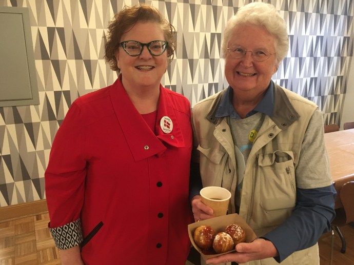
Pancakes
First, we stopped at the Danish American Center, a building we have passed innumerable times along West River Road in Minneapolis. Over a hundred years ago it began as a home for seniors, today it is a community center and offers overnight lodging for out of town visitors to members. All Doors Open visitors received a personal tour and a serving of Danish pancakes, a round pastry called an Aebleskiver.
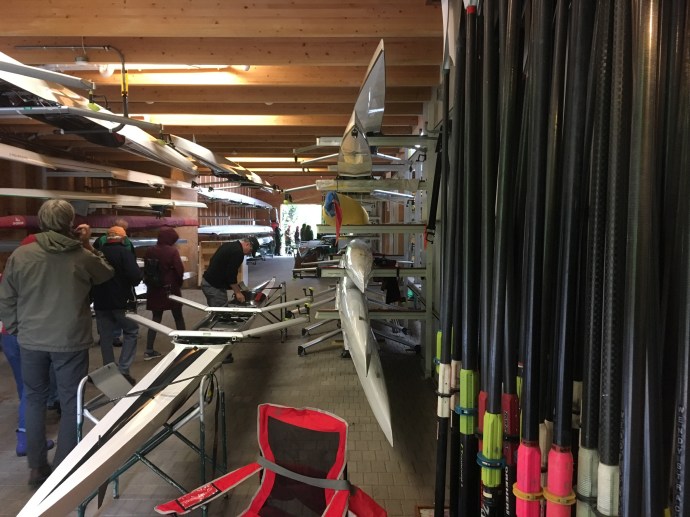
Minneapolis Rowing Club boathouse
Our second stop was at the Minneapolis Rowing Club. Their boathouse along the Mississippi, after their previous A-frame building burnt down in the late 1990s, is designed to resemble a duck in flight. Inside we were treated to a tour and discussion of rowing; single, double, four and eight person. Note: if a rower uses two hands to hold two oars, it is sculling. If a person holds only one oar with both hands, it is called sweep rowing. As you walk in, you are overwhelmed with the rows of boats, the lined up oars, and the second floor exercise room. The exercise area can have one wall opened to provide fresh air and an up-close view of the Mississippi River. All ages are welcome, we talked with one woman who had just begun rowing three years ago when she retired.
In an interesting note, at St. Anthony Falls Lock and Dam on Saturday, numerous visitors asked about the publicized study being undertaken by the Army Corps of Engineers to determine the fate of the lock which was closed four years ago. No answer is expected for 18 months; implementation will take longer no matter the recommendation. One option discussed has been to remove the lock and allow the river to flow freely. This would likely eliminate the ability of the rowing club to practice on this stretch of the river.

Flood waters at Crosby Farm Regional park in St. Paul on April 26

May 20th at Crosby Farm park

May 20th at Crosby Farm Park


The family swimming in Crosby Lake

The flood residue is over 7 feet high on this tree
Monday night I explored Crosby Farm Park, located across the street from our condo. The trail has been closed for weeks due to high water. On my visit Monday, the water has receded in most places leaving behind muck and debris. The woods were full of bird songs, chirping and tweeting and honking. A few hardy bicyclists had taken the path, I could see their trails in the mud. One couple was walking along, when they reached the inch or two high water crossing the path, the woman climbed on the back of the man who carried her over to the next patch of dry pavement. One pair of Canada Geese were perched on washed up grasses on the path, they moved into the water and swam away as I approached. 100 feet further on, another pair did the same only this time they had their eight or so chicks in between them. With more rain coming, it will be a while until the paved path is free and clear.

Wolf diorama at the Bell Museum
Wednesday night, May 15 we returned to the Bell Museum to listen to a talk about wolves. Two University of Minnesota researchers have been studying wolves in Voyageurs National Park. This multi-year study was one of the first, if not the first, to capture wolves on film catching fish in a stream.
As a supplemental treat, the Bell has a three week exhibit on the Moon, closing Sunday June 9th. The view of the lighted moon is spectacular. A 20 minute presentation was offered to tonight’s visitors so we added two experiences for just one trip.
We hoped you enjoyed this post, just a note about different activities that are available to one, even in your home town.
Ed and Chris St. Paul May 23

Como Park Conservatory, St. Paul MN


 Teddy Roosevelt slept here at The Fells and planted a tree on the property which is still growing.
 The Fells building
 The Robert Shaw Memorial-original in Boston Commons-from the Saint-Gaudens National Historic Site in Cornish NH
 Driving along New Hampshire highways
 Two of Saint-Gaudens major works
 Aspet House, Saint-Gaudens home in Cornish NH
 Inside the Marsh-Billings-Rockefeller mansion
 walking the grounds at Marsh-Billings-Rockefeller
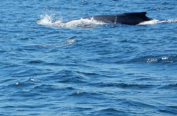
 View from our room towards Good Harbor beach.
 Saturday morning at Good Harbor Beach
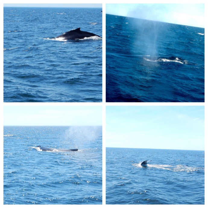 Our whale
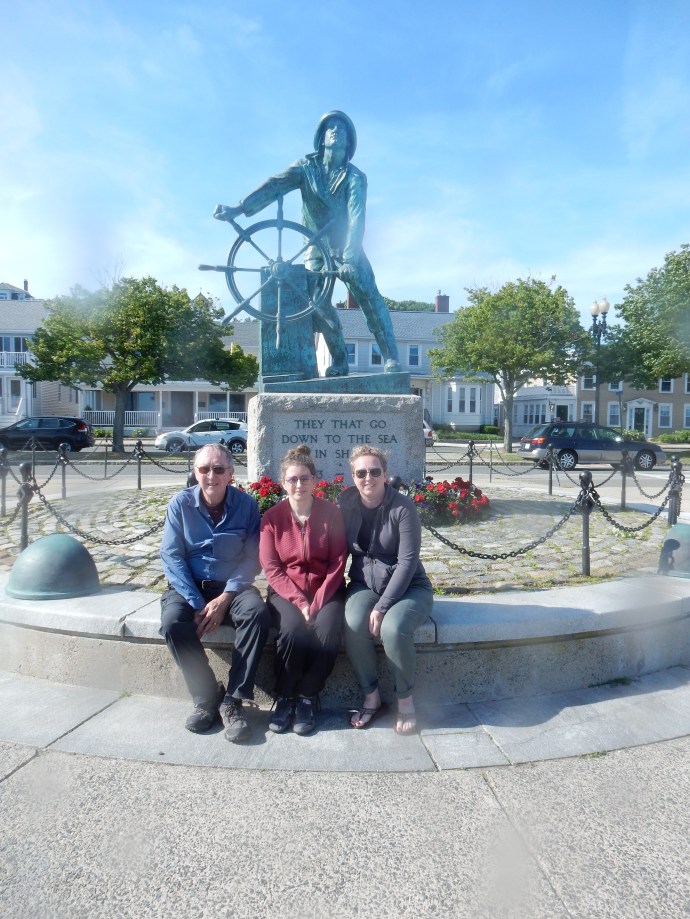 Man at the Wheel statue
 Our Lady of Good Voyage church in Gloucester
 Ed enjoying the art in Rockport

Recent Comments