Follow Ed Heimel and Chris Klejbuk as we explore the USA and Canada. Trips began in 2013. See sidebar. Since Jan. 2013, over 220,000 miles traveled and 1100 days on the road. Over 700 blog posts written. 2023-We are closing in on 350th National Park unit. Photo below is Pacific Ocean by Big Sur, CA
About Ed Heimel and Chris Klejbuk, MN travel bloggers; ckeh72@comcast.net
We are a husband and wife team living in St. Paul MN. Both of us retired by the end of 2012 and decided to travel and visit areas of the U.S. and Canada that we had not seen before. Most of the time we head out for 3-7 weeks; usually by driving, first in our 2001 Saturn and then when it hit 225,000 miles we traded it in for our 2016 Subaru Legacy . This travel blog is written to help us remember the great places we have visited and people we have met as well as to inform family and friends of our whereabouts.
Contact us at ckeh72@comcast.net
In 2013 we took the following trips: Trip 1-January--2 weeks in Florida to visit Orlando, St. Augustine, Jacksonville, Amelia Island. Trip 2-February and March-4 weeks in Hawaii, visiting the four major islands. Trip 3-March and April--several weeks in New Mexico visiting family followed by traveling cross-country to VA for VA Garden week. Trip 4-May and June--6-7 weeks driving to Las Vegas, the Sierra Nevada Mtns, Yosemite, Kings Canyon, Sequoia N.P, Salt Lake City, Grand Tetons, Yellowstone, Devils Tower and home. Trip 5-June- a quick trip to Boston to visit family. Trip 6-July and August-a 6-7 week trip to Calgary, Banff, Mt. Ranier and Mt. St. Helens, Olympic N.P., North Cascades N.P., Victoria, Vancouver, Whistler, Revelstoke, Jasper, Yoho,Whitefish lake, Theodore Roosevelt N.P. Trip 7-August and September- our daughters wedding in MD and returning home through the Upper Peninsula of Michigan. Trip 8-October and November-3-4 weeks in the Ozarks, Arkansas, Missouri. Trip 9-December and January 2014-Christmas in Santa Fe and New Years in Flagstaff and points in between.
In 2014 we took the following trips: Trip 1--a week in Ely MN, most of it dog-sledding in late Feb. Trip 2--6 weeks in the Deep South including LA, MS, AL, GA and FL in March and April. Trip 3--a trip to Boston to visit family Trip 4--May and June houseboating on Lake Powell followed by Monument Valley, Arches and Canyonlands N.P, Black Canyon of the Gunnison N.P, San Juan Mtns of CO Trip 5--time spent in MN and the Midwest Trip 6--visiting Ontario, Ottawa, Montreal, Quebec, the Adirondack Mtns of NY, our daughters wedding in CT and home through Philly and Ohio, 7 weeks in September and October. Trip 7--Southern California including Joshua Tree and Mojave Desert N.P, Anza Borrego Desert State Park, and then to Flagstaff for Thanskgiving for three weeks in November.
In 2015, we took the following trips: Trip 1- 8 weeks traveling around FL in February and March, most of it on the panhandle, penninsula and Gulf Coast. Trips 2 and 4 to Boston in April and July. Trip 3 was to Isle Royale National Park in Lake Superior. Trip 5 was to southern MN. Trip 6 was to Voyageurs National Park and northwestern MN. Trip 7 was to the Great Smoky Mountains and neighboring areas.
In 2016 Trip 1 was to Chicago IL. Trip 2 was to southwestern MN. Trip 3 was to Boston. Trip 4 was to southwestern United States. Trip 5 was to Lake Superior. Trip 6 was to Winona MN. Trip 7 to western Massachusetts (the Berkshire Mountains). Trip 8 to the Rocky Mountains in Colorado. Trip 9 to Boston and Rhode Island.
In 2017, Trip 1 was to the Mississippi River Headwaters. Trip two will be a month long tour of Texas and another month traveling to and from Texas across the southern US.
Image
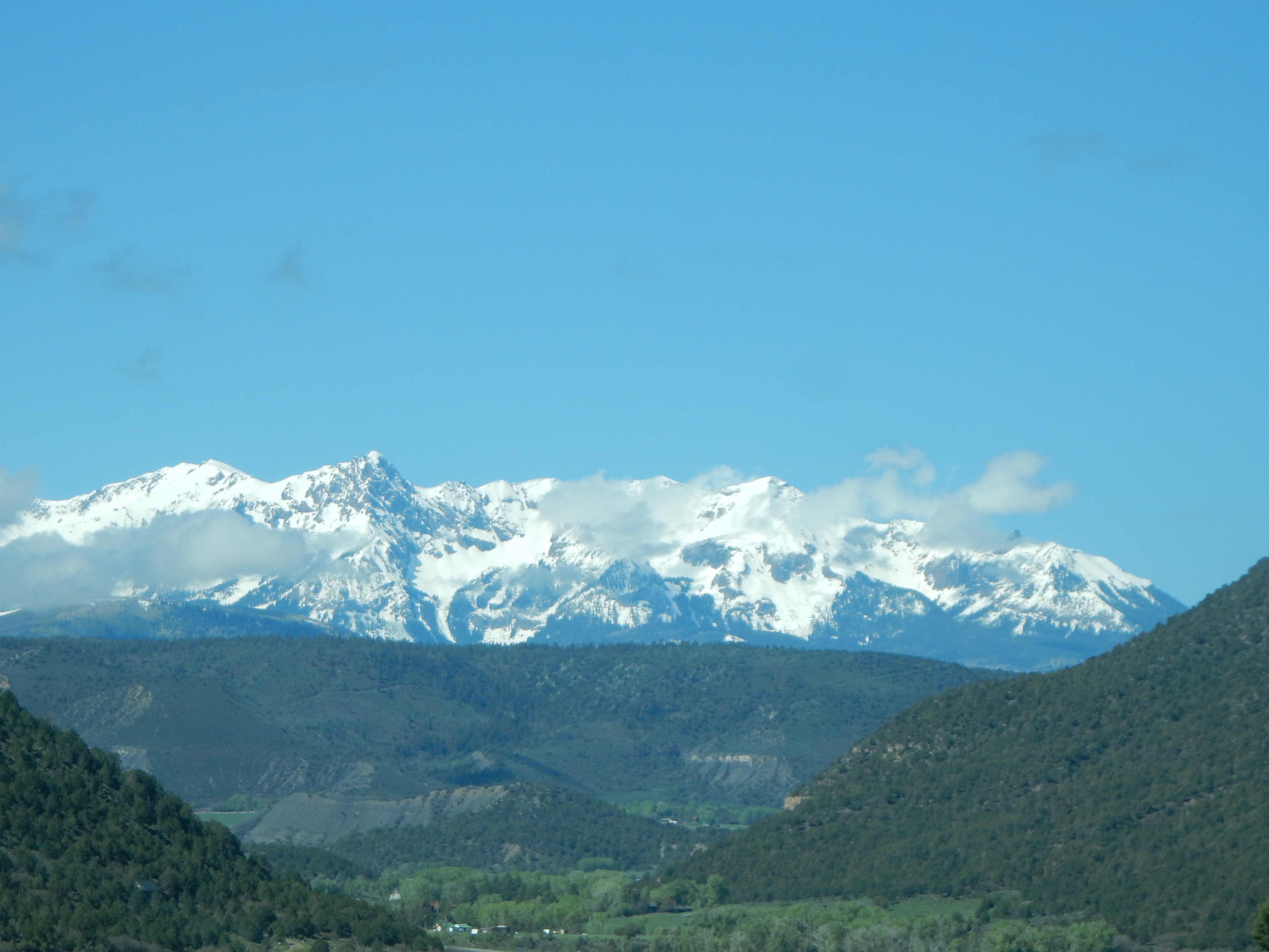
Mountains are now surrounding us. Ridgway is at 7,000 feet in the San Juan Mountains. The San Juans have 14 of Colorado’s 53 peaks over 14,000 feet. This morning we drove past Ridgway and went another 20 miles to Ouray.
San Juan Mountains
We visited two falls in Ouray, and even did some shopping. Falls number one was Box Canon Falls which drops 285 feet into a narrow canyon. We took the lower route to watch the water splashing and passed up on the opportunity to climb to the top and watch it from there. The falls were never commercially used and were donated to the city in the early 1900s. The area is also used for ice climbing in the winter.
Box Canon Falls
Cascade Falls is out in the open and while there is a longer hike to the top, we just hiked to the lower viewing area. These falls are supposed to be 120 feet tall.
Cascade Falls in Ouray, CO
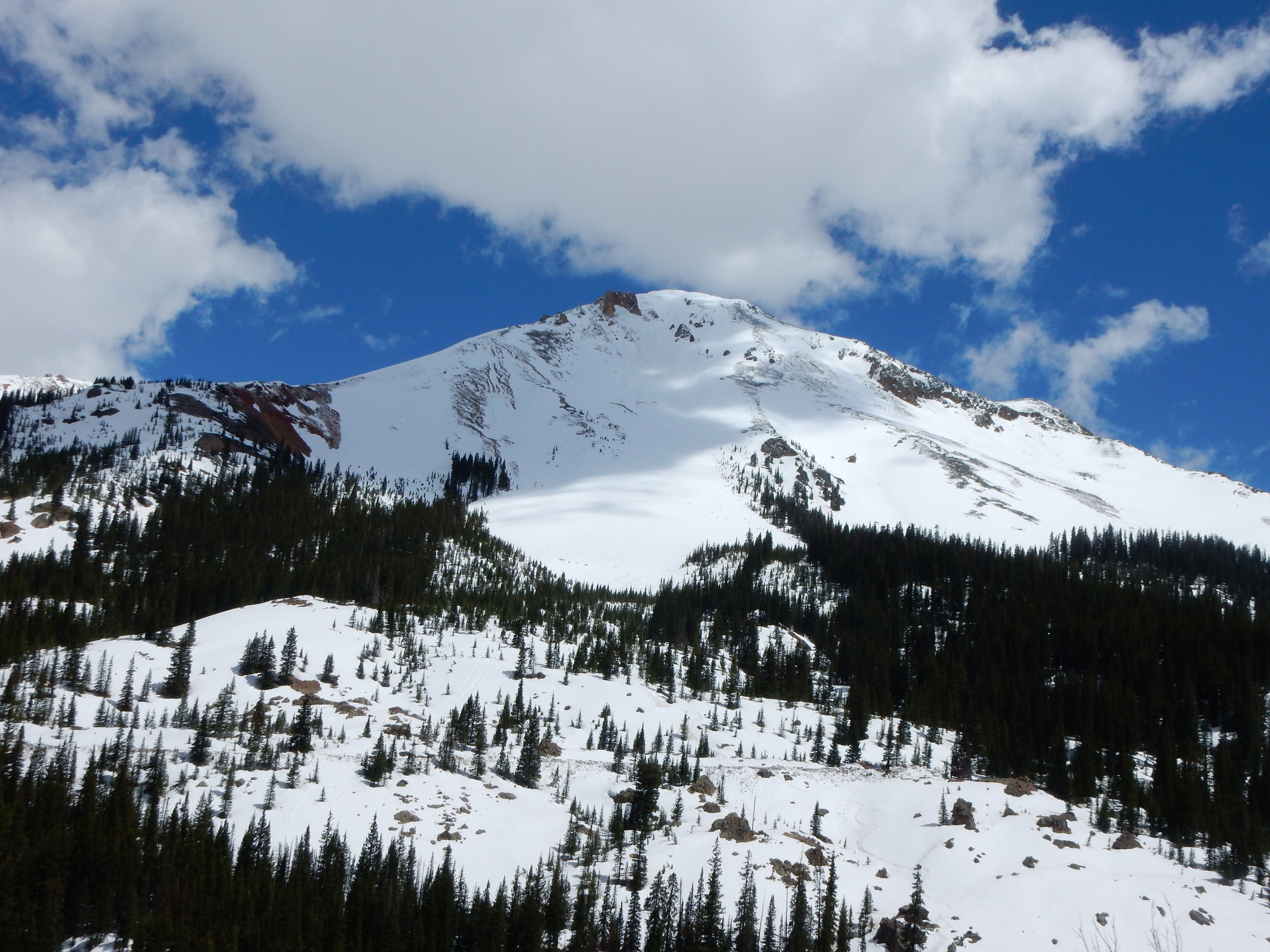
After lunch and shopping, we drove the “Million Dollar Highway” to Silverton, CO. This is a 25 mile section of the San Juan Scenic Byway which is a 230 mile loop road. This section goes over the Red Mountain Pass at 11,000 feet and is supposed to be the most scenic portion of the byway. It took us close to an hour to make the drive to Silverton. Silverton is an old mining town, silver being one of the primary minerals mined here in the 1800s and early 1900s. Now the town is the turn around point for the Durango and Silverton Railroad, a tourist, scenic railroad.
Waterfall along San Juan Byway
View along the San Juan Skyway between Ouray and Silverton
We passed numerous spring waterfalls along the road, old mining shafts, and roaring creeks. The sky was primarily clear so the blue skies and white, snow-capped peaks made for a scenic contrast. Of course, we had to get back to Ridgway for our night’s lodging so the return trip took another hour. But the beauty was worth it.
A rare view of red rocks today
Dinner was in Ridgway at a local diner with $5 burgers tonight. With a cup of soup or other side included, it was a pleasant way to end the day.
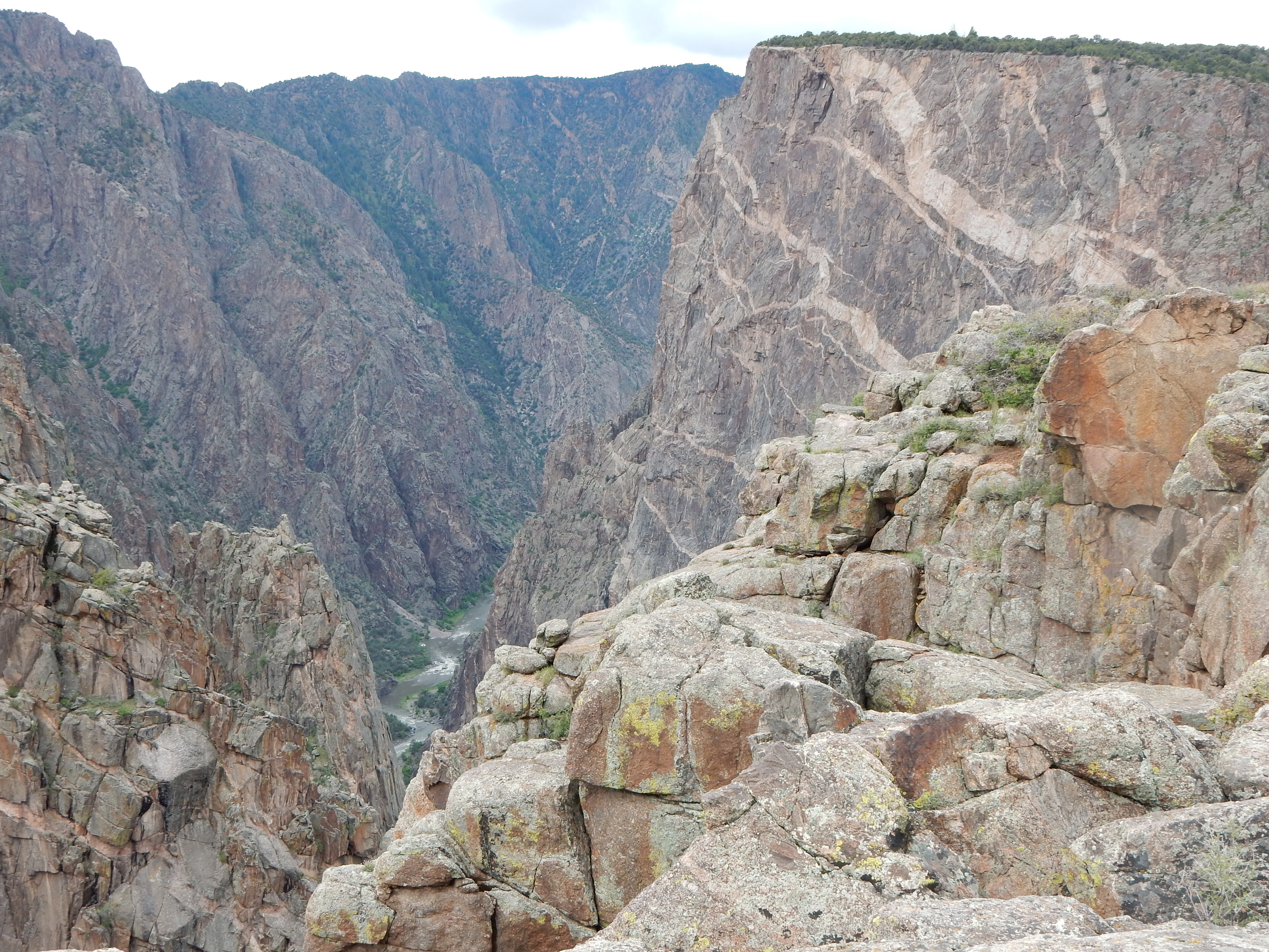
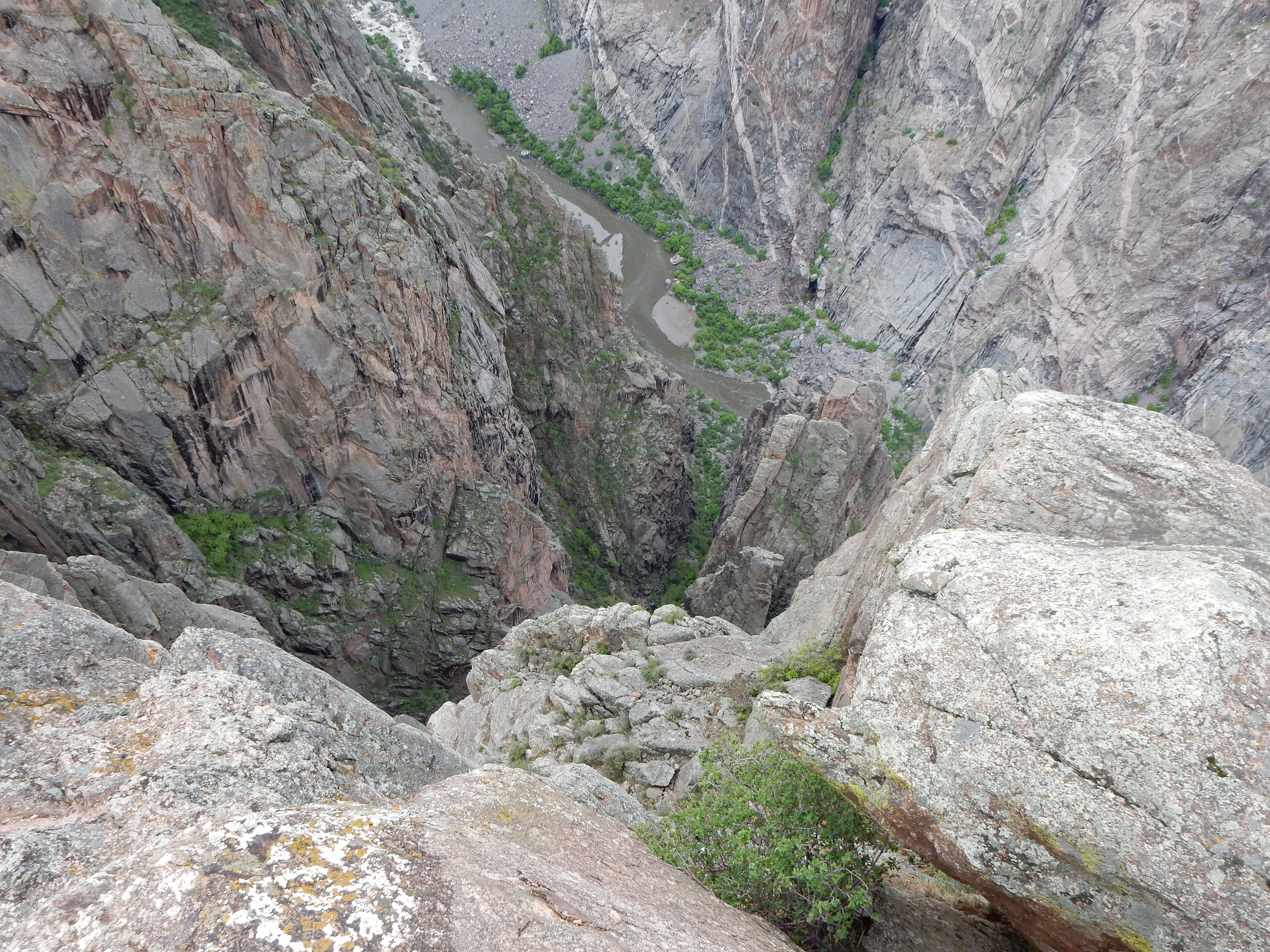
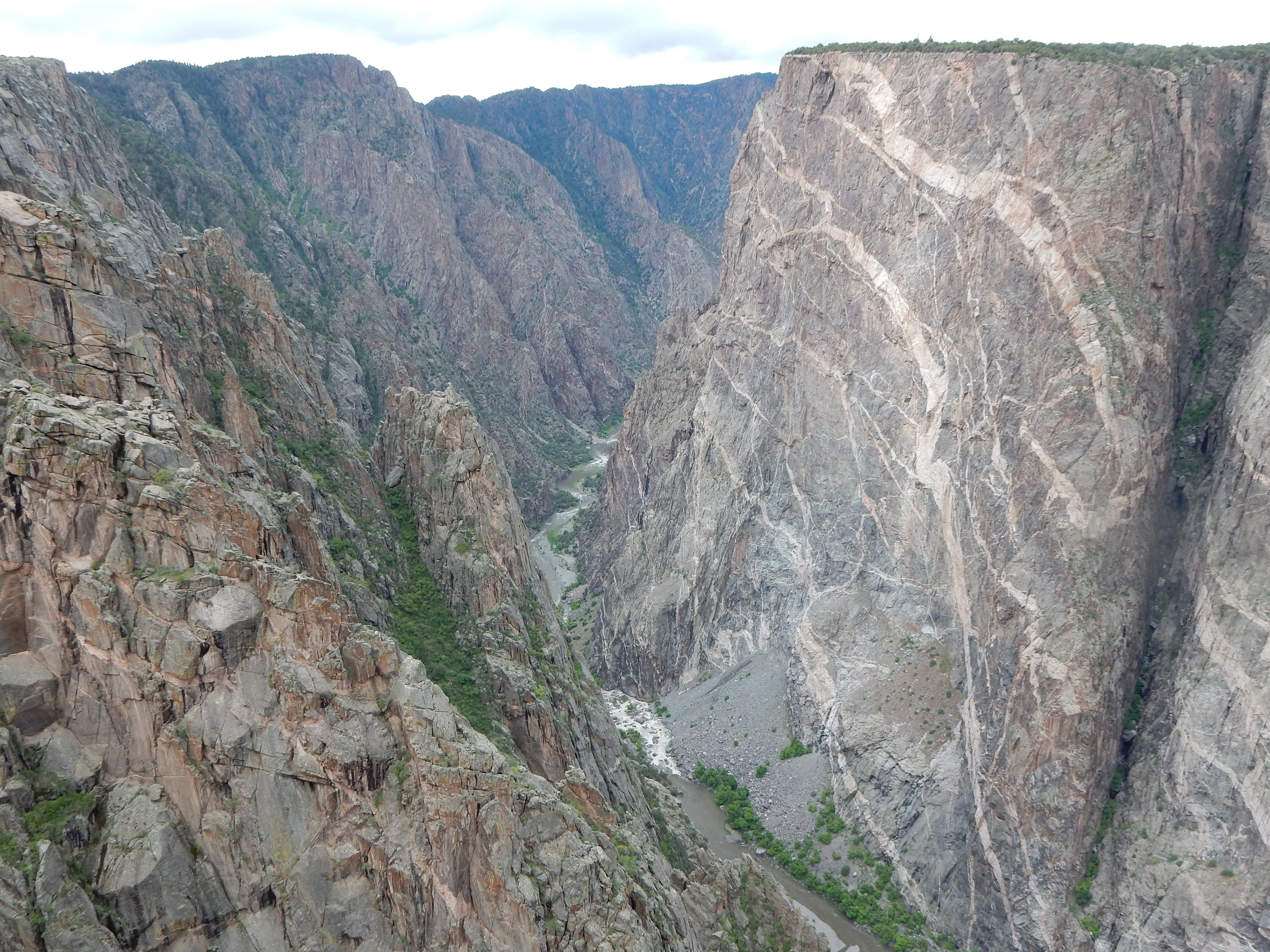
Our major experience today was the Black Canyon of the Gunnison National Park. The Black Canyon has been described as: “But no other canyon in North America combines the depth, narrowness, sheerness and somber countenance of the Black Canyon of the Gunnison.” Its river rafting rating is Level 5 to unnavigable. So we did not raft it or swim it.
Our visit was confined to the south rim trails and overlooks. This was stunning enough. The bottom is dark due to little sunlight. (It did not help that today was overcast.) In just 48 miles, the river drops more elevation than the entire Mississippi from MN to LA. At its highest, the walls are 2772 tall.
I believe the best way today is simply to present pictures. Enjoy.
Arches National Park lured us back for another visit. We went to “Park Avenue”, a hike among towering cliffs versus arches. Park Avenue is an out and back hike unless you have two vehicles and can leave one at the far end. The hike descends 320 feet and out for a mile, and then back again. Not overly strenuous and it gave us some great views of the cliffs and the interplay with the rising sun. Wildflowers were abundant along the route and you can view the ripple action of ancient seas as they laid down layers of sand.
Along Park Avenue trail
Park Avenue hike view
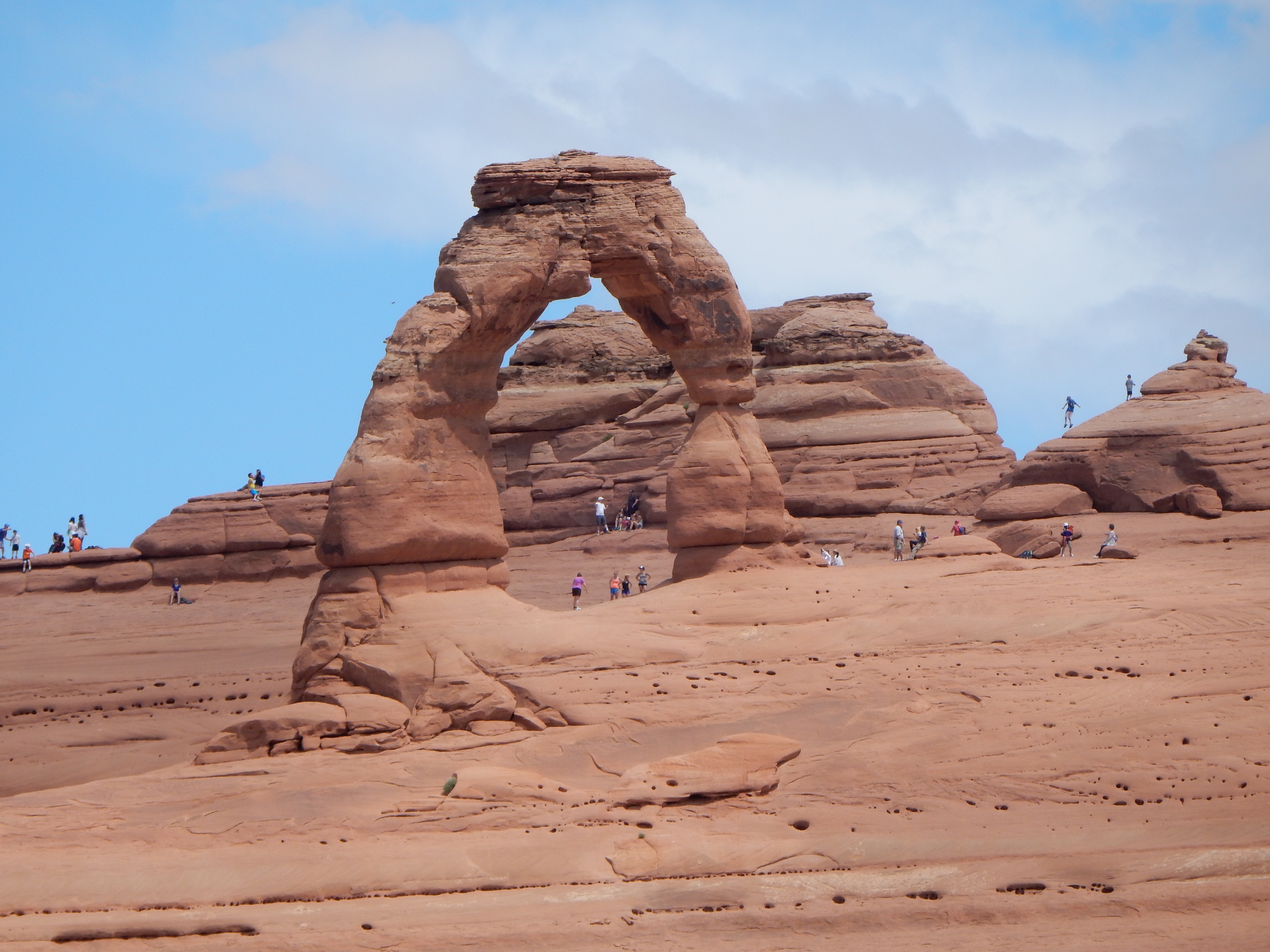
We toured the visitor center and film and then went to “Delicate Arch”. We were not overwhelmed, supposedly it is one of the most photographed arches in the park. The late afternoon even produced a rain storm, enough to cause sand to run over sidewalks and roads.
reflection in rain water
In the evening, we went to a lecture at the local history museum. The featured speaker was Mark Steen, one of the sons of Charlie Steen, the man who found the uranium that lead to Moab’s uranium rush and got rich-at least for a while. It was a fascinating 90 minute presentation. I think he could have gone on for days about stories of the uranium rush days.
Delicate Arch
Between he and Kristen, we obtained a picture of a small community in the early 1950s with no indoor plumbing, unpaved streets, long distance phone calls limited to three per day for the entire community, etc. This area of Utah was still way off the beaten path.
The Steen family lived in trailers and shacks. Dad prospected with various results for several years. When the mother lode was hit, the Atomic Energy Commission was disbelieving and unhelpful because the strike was in an area with ores they had labeled as not commercially viable. Charlie Steen helped others make friendly claims and they profited. Some people did not act on Charlie’s advice and lost out. The Steen family spent their own money to make improvements to the town. According to Mark Steen, there have been studies that state this uranium boom had a bigger financial impact that the Gold Rush in CA or the Klondike. Like many rags to riches stories, not all ended well. There were legal wrangles, tax issues, etc.
Saturday, May 24
We have seen a lot of red rock in the past week or so. Today we head for Colorado and mountains (still rock, of course) but also water and forests.
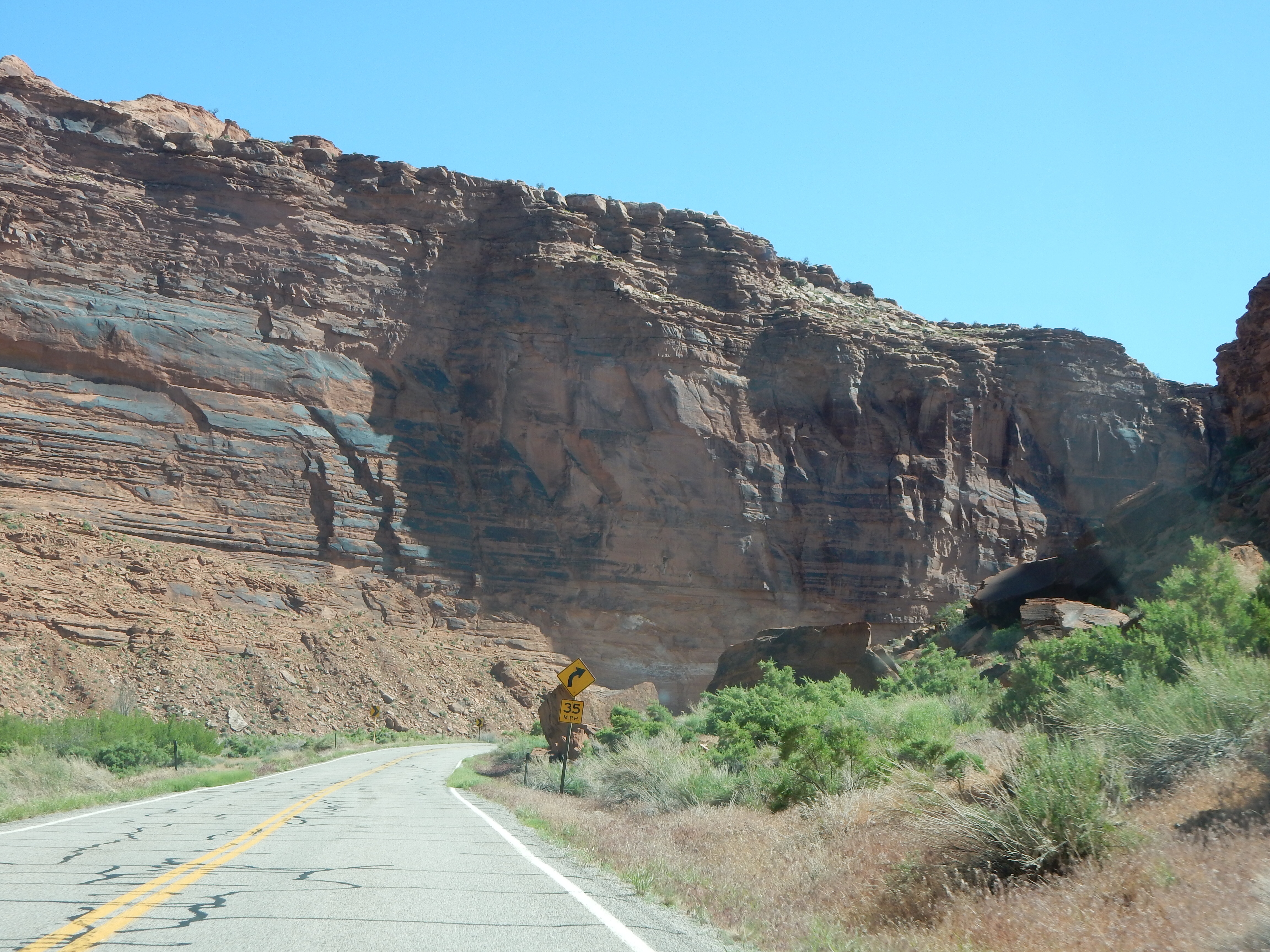
Leaving Utah and heading for CO
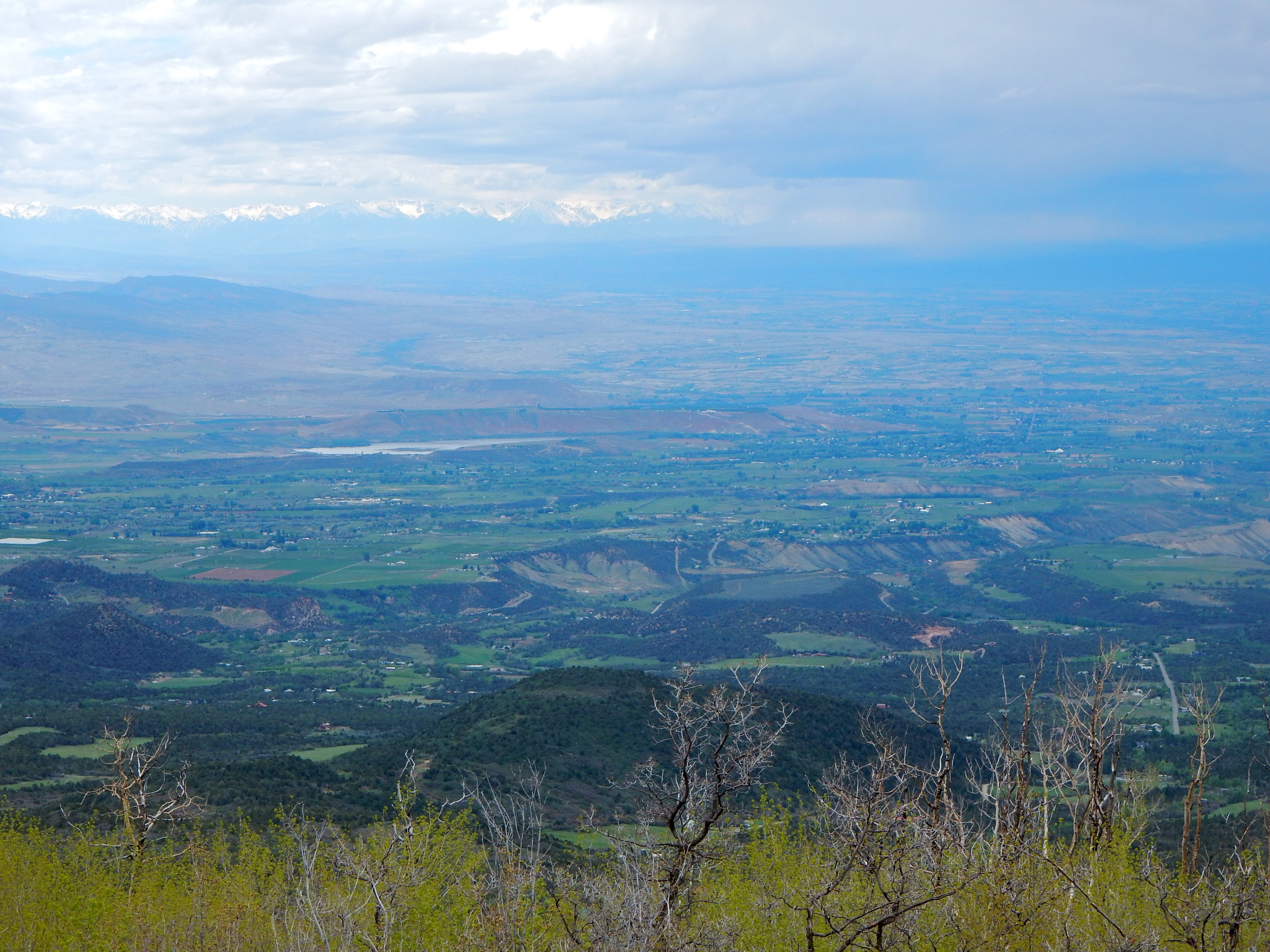
We took the slower, more scenic route out-of-town along the Colorado River. Eventually we left behind rock climbers, river rafts, and red rock for flatter land away from the river. As we continued on into Colorado, the river and cliffs returned. We stopped at the CO Visitor Center and decided we had enough time to add a scenic byway on our way to Montrose.
Along the Grand Mesa scenic byway
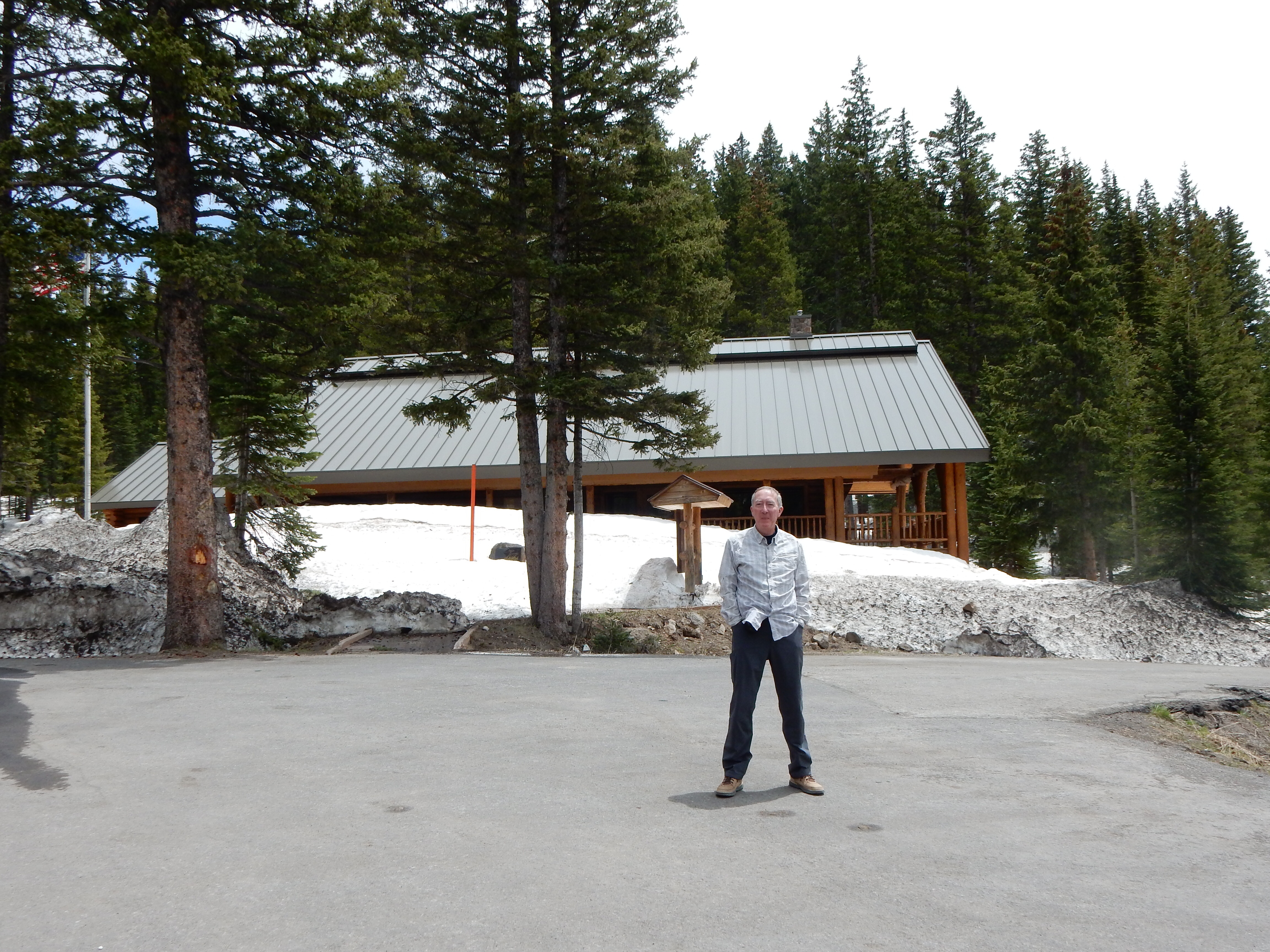
The Grand Mesa Scenic Byway is 63 miles in length and ascends from 4600 feet to 10,800 feet; but this time it was all on paved, two lane roads. Along the side of the road, a creek is roaring with melted snow on its way to the Colorado. We went from the arid desert to snow and aspen trees. The Grand Mesa is just SE of Grand Junction and is reputed to be the “largest flat top mountain in the world”. There are over 300 lakes on top of the mesa and water collected here feeds irrigated lands in the Uncompahgre valley which is now a major agricultural and fruit-growing area. Many of the lakes are still frozen, we did see some men fishing at one reservoir where a small portion of the ice had gone out.
Along the Grand Mesa scenic byway
at the visitor center for grand mesa
Lunch was in the small town of Cedaredge. The restaurant boasted several boutiques, an art gallery, and a winery. It was a lucky choice to stop at.
Montrose is our home for two nights. Tomorrow we plan to visit the Black Canyon of the Gunnison, another national park.
Moab matured into its modern manifestation of a tourist destination due to mountain biking. Hard to imagine, but the two-wheel mountain bike riding experience has morphed into a locale for mountain biking, river rafting, BASE jumping, rock climbing, off-road vehicle driving, along with simple hiking at Arches and Canyonlands.
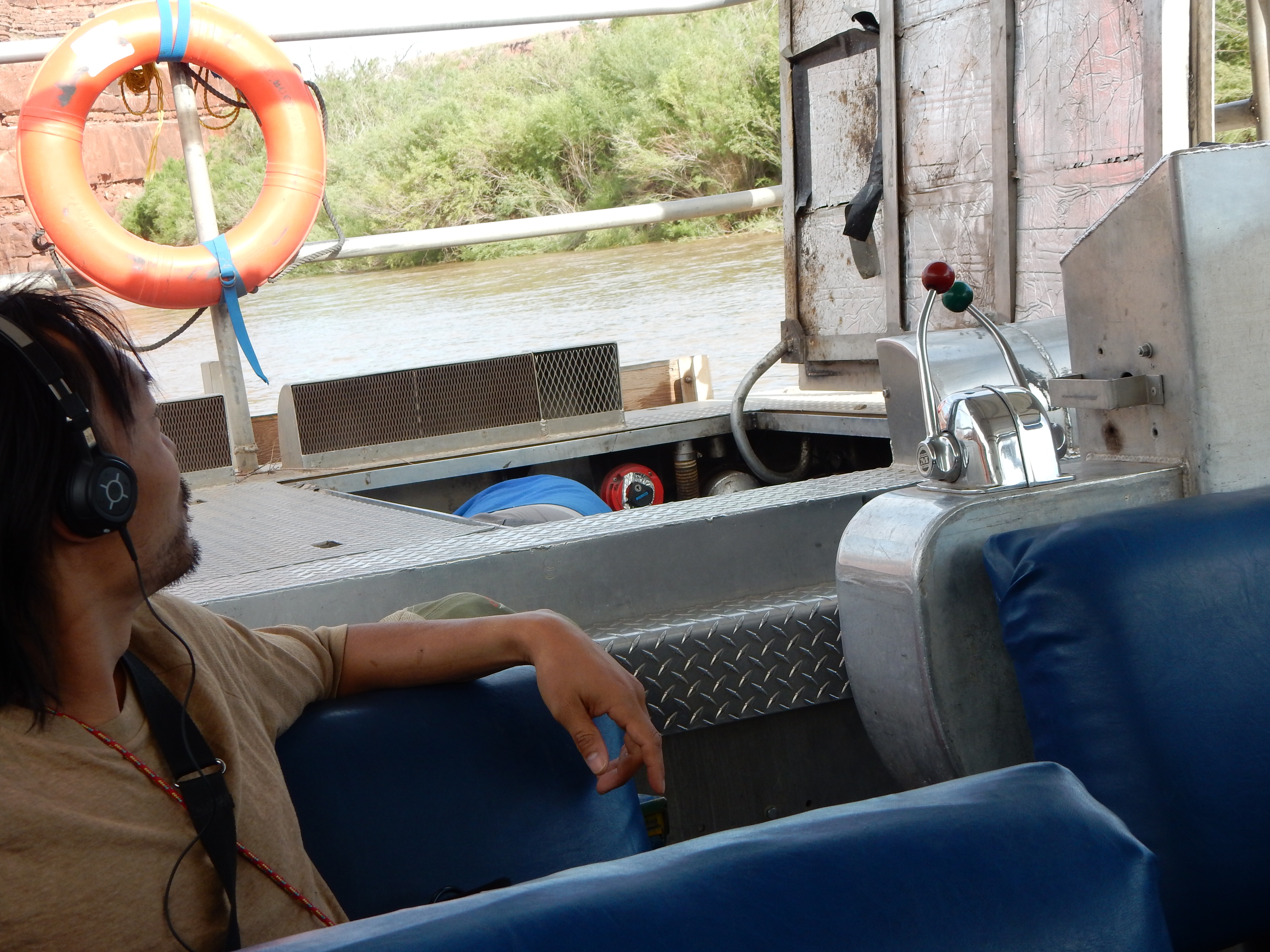
Adventurous souls that we are, Thursday was our day to get our toes wet in these experiences. 7:30 to noon was riding the Colorado river on a jet boat. 1 to 5:30 pm was riding back roads on BLM (Bureau of Land Management) land in a 4 wheel drive vehicle. Tag-a-long Expeditions was our toe dipper.
Our boat
The jet boat ride begins with the group riding in a school bus and towing the boat to the Colorado. Among our group were two guys from Denmark filming a promo for Tag-a-along for the Danish market. Another couple were a mother and her adult son. The son took the place of the husband/father who was scheduled to be on the trip but on day one of their experience, he broke his right arm mountain biking. They had not yet determined who was going to drive the truck with attached tow behind RV they had here. The mother does not drive it.
Colorado river
Our drive took us past the uranium mining tailings reclamation site and the potash mining site. Potash used to be mined underground. After an accident causing fatalities, they decided to pump Colorado river water into the mines, allow the water to absorb the mineral, pump out the water and allow it to evaporate leaving only the potash. (They now dye the evaporation ponds blue so it is more aesthetically pleasing.)
Removing sticks from the impeller
The boat takes off from a landing spot on the Colorado River and as a jet boat does not need deep water to operate. However, the impeller does need to be free of impediments. At today’s high water level, sticks and logs in the river are a major concern. The boat operator had to stop the boat three times and let it drift in the strong river current while he removed sticks manually.
Colorado river
But the view is fantastic. Despite the phrasing of the tour literature, we do not tour Canyonlands National Park, we tour the canyonlands area prior to the park boundary. But the only good views are not within the park and we are enjoying the scene. There is some bottomlands but the red canyon walls are the predominant feature.
At one point, we beach the boat and hike along the bank to a site with some petrified wood and nice wildflowers. The flowers are vivid and varied, we lucked out in our timing of this trip.
On the return trip to Moab, we pass a site with Fremont Indian petroglyphs. A little further along about 30 people are rock climbing.
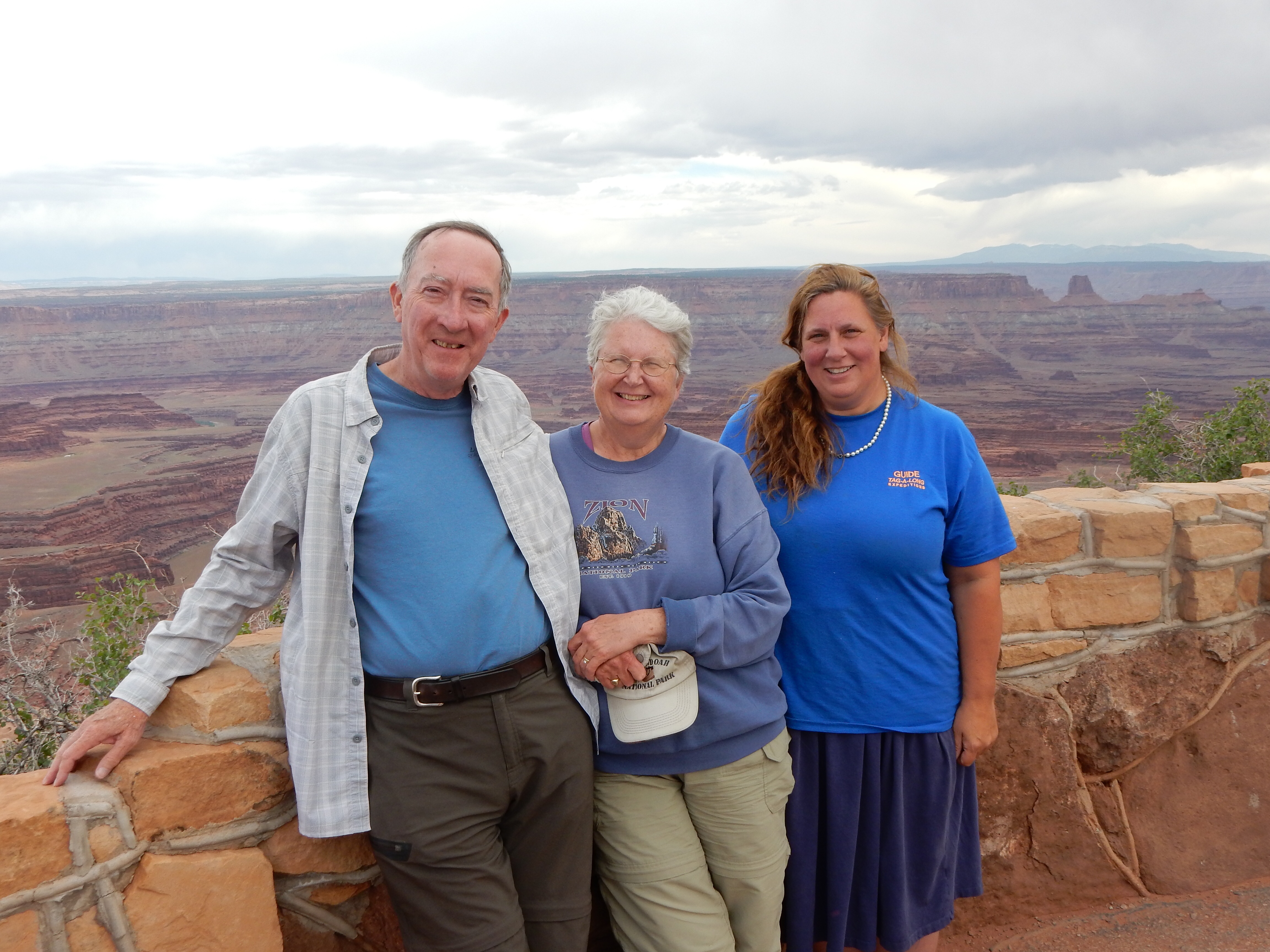
Ed, Chris and Kristen
Lunch is sandwiches at the tour site and then we are off with Kristen in the 4 wheel drive vehicle. The mother and son combo are with us on this trip. It is not an extreme Jeep or off-road vehicle but a high clearance, wheel drive Suburban type. (Two of their four Jeeps are in the shop for repairs.)
Canyonlands view
Our first experience is a doozy. While we have driven curvy mountain roads with sheer drop offs, I had no reluctance to allow Kristen to be the driver on this excursion. The road was more rock than gravel, was two-way but one lane, had sheer cliffs on one (Chris’) side, and we shared it with some mountain bikes. This first drive, along with the last one, had an elevation change of about 1500 to 2000 feet of cliff hugging roads. I doubt the pictures do it justice. I am sure for many people, it would be a simple drive to work but it was plenty adventurous for us.
Mountain bikers looking at Gemini Bridges, twin arches with crevasse
Once at the top, the road surface did not improve but now we were driving along the mesa top and looking down and across. BLM land is managed for multiple uses so this area includes marked mountain bike trails, off-highway vehicle trails, and oil drilling.
View from Dead Horse Point including potash ponds
We did make a stop in Canyonlands Park and at a state park, Dead Horse Point State Park. From Dead Horse Point, we could view the potash mining ponds and several movie filming sites. The Moab area seems to compete with Monument Valley for film-making. Kristen said that some film makers have a hard time dealing with the cash only policy on the Navajo lands.
Driving down Longs Canyon
The final scene from “Thelma and Louise” where they drive the car off the cliff was filmed in this area as was a section of Tom Cruise’s Mission Impossible II.
View from Long’s Canyon
Our drive home was less cliff threatening but just as bumpy, steep, and thrilling. The day was a full one with plenty of new experiences.
Ed and Chris May 23
Attached are two videos. The first is a short portion of the Colorado River trip and the second is a brief section of the drive back to Moab Thursday afternoon down Longs Canyon.
Canyonlands National Park preserves a wilderness of rock. There are three separate areas, one is completely wilderness for diehard hikers and campers. Obviously not us. The main section is called Island in the Sky and is likely to be where we spend most of our time. The Colorado and Green Rivers divide the various sections and then meet at the end of Island in the Sky.
The Colorado River is very brown with silt. The Green River originates in WY and looks green due to minerals in its drainage basin. Originally the Colorado River was not considered to start until the confluence of the two rivers. From its origin in Grand Lake CO, in the Rocky Mountains, the river had been known as the Grand River. In 1921, the State of Colorado petitioned the US to rename the upper section as the Colorado also and over Utah and Wyoming objections, it was renamed. The Green River covers a larger drainage area prior to the confluence but the Colorado’s volume is higher.
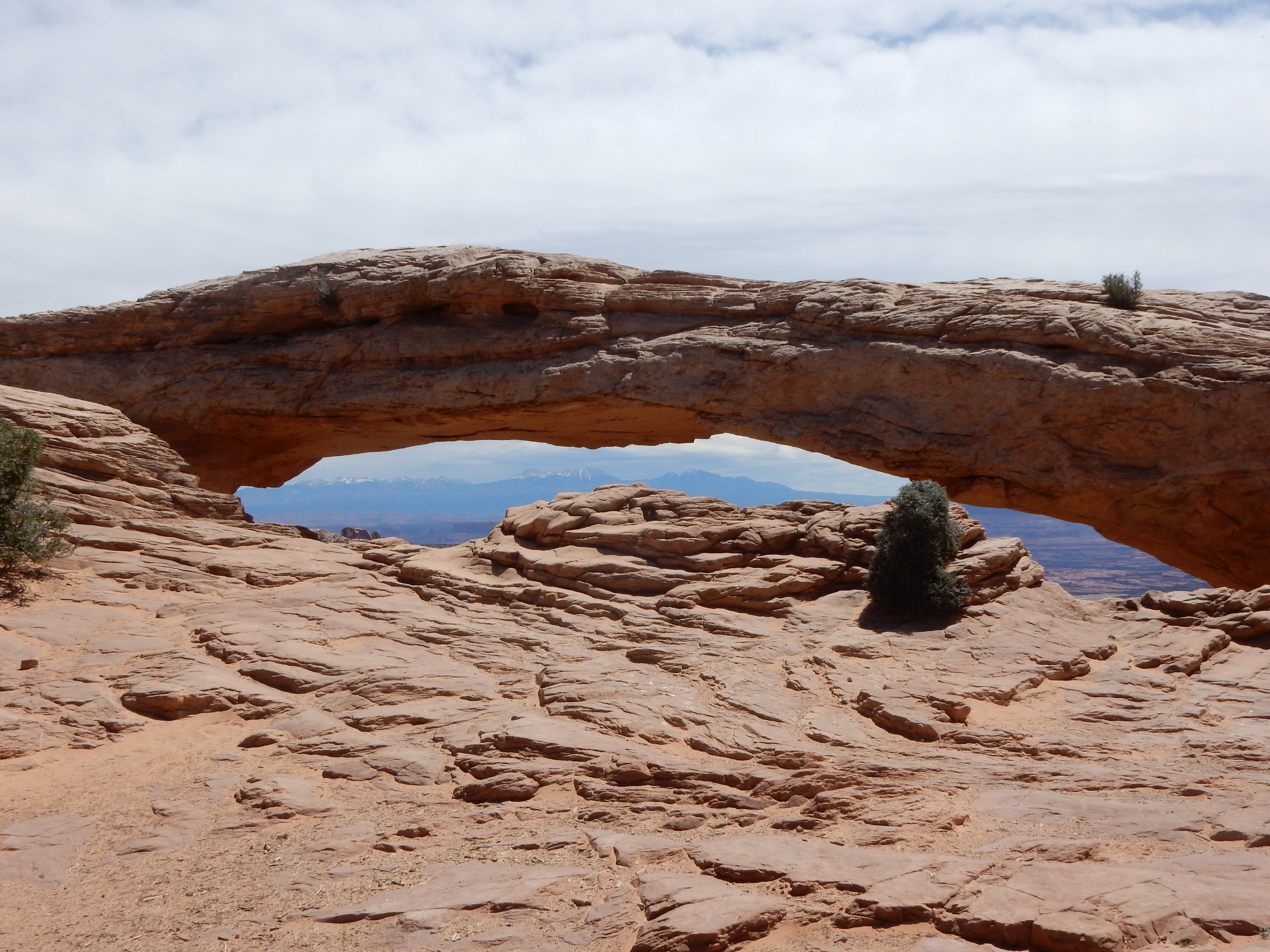
View from Mesa Arch in Canyonlands NP
We began Wednesday at the Visitor’s Center at Island in the Sky and listened to a park ranger (the one from West St. Paul) discuss John Wesley Powell. Powell served in the Civil War where he lost the lower portion of his right arm. He was an adventurer from early on, traveling down the Mississippi from St. Paul to New Orleans by himself.
Powell gathered together an expedition, funded by himself, family, friends and donations, some left over US government property after the Civil War. He and 9 others, none with previous whitewater river experience, left Green River WY on May 24, 1869 to explore the previously unmapped and never successfully journeyed section of the rivers from Green River down to the Grand Canyon. When they reached their end point, they had 10 pounds of flour left. One of their group left early on, three others left and were never heard from again.
Powell’s exploration opened up this area of Utah, previously marked on maps as “Unknown”. He had advance thinking and suggestions for his time, suggesting that the river resources should be husbanded and shared. Most suggestions were ignored.
Mesa Arch
After education, it was time for exploration. One of our first stops was Mesa Arch with a great view of the La Sal Mountains in the east. However, the wind was ferocious and it was like being sand blasted. We put up the hoods on our windbreakers and stood with our backs to the wind to ease the hassle.
Green River
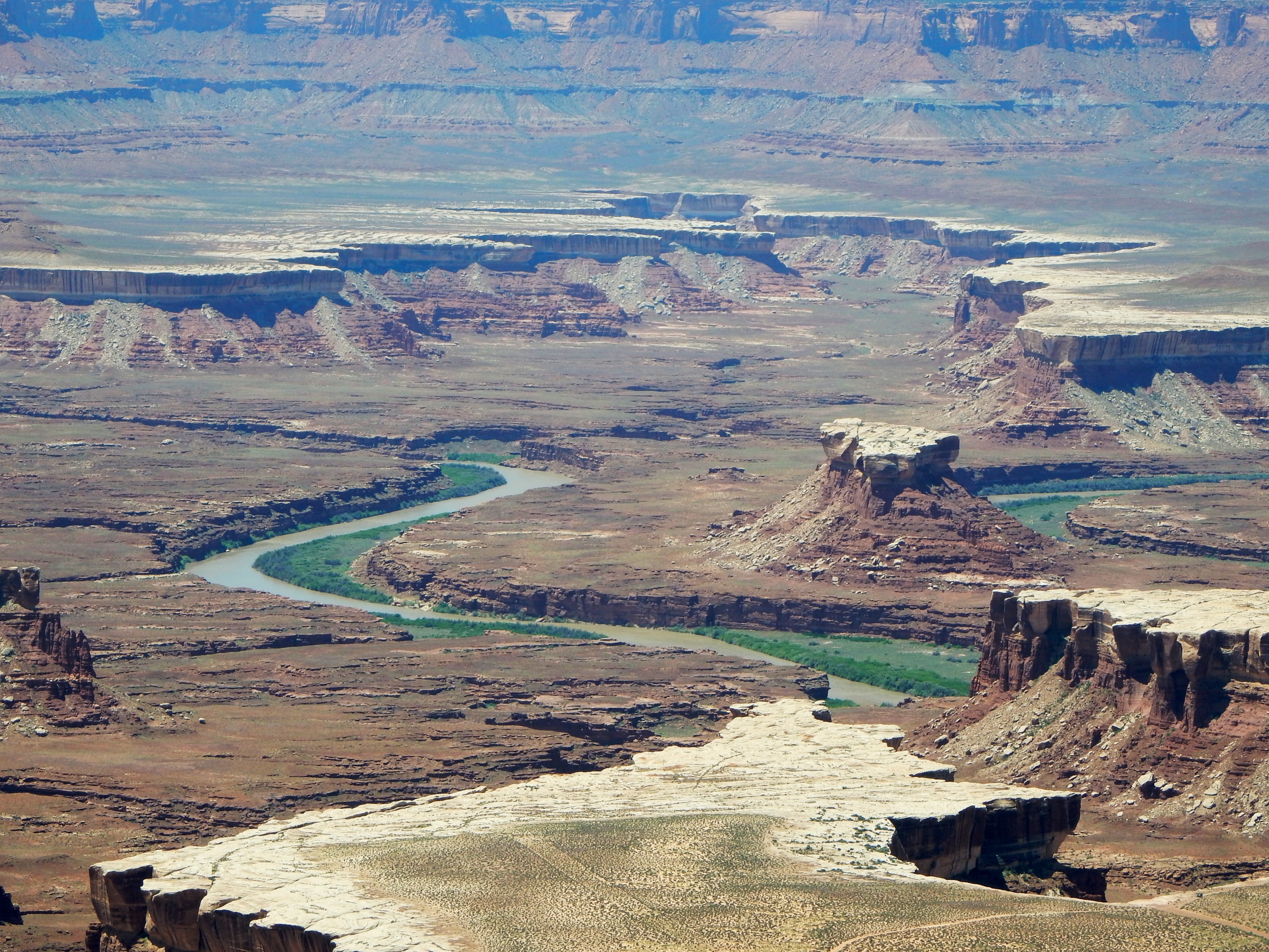
Lunch was peanut butter and crackers at one of the overlooks and then it was on to the Green River Overlook. All of these views are from higher elevations looking down at the rivers. In fact, once the Colorado leaves the town of Moab and enters the “Portal”, it is surrounded by cliffs for something like 500 miles.
Green River
You look down into this great, deep valley/canyon and can see the river in the distance with these steep cliffs descending from your location. It is quite an amazing sight.
Our final stop was at Grand View Overlook. It is the farthest point south casual visitors can go at Island in the Sky. In the far distance is the confluence of the Colorado and the Green followed by Cataract Canyon where the whitewater rapids are especially potent as the combined volume rushes through a narrow canyon. Todays flow was quite strong as the mountain runoff in Colorado is strong but not yet at its peak.
Vista from Grand View Point
Dinner was at a local BBQ restaurant which we chose since it had local musicians playing that evening. The food was fine, the music just bearable. Tomorrow morning we get up early for a full day of adventure.
Moab Utah Wednesday May 21 for Monday-Tuesday May 19-20
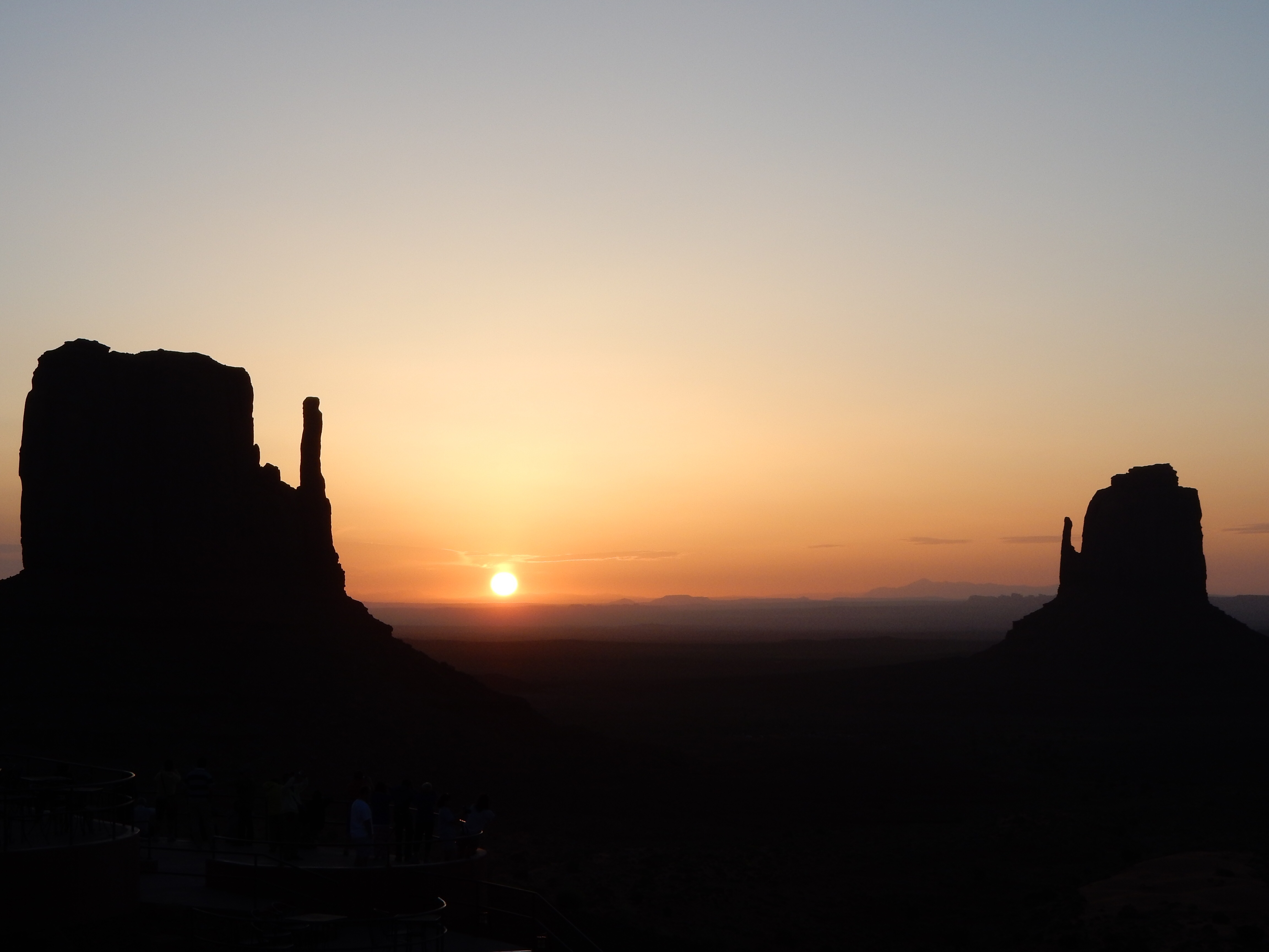
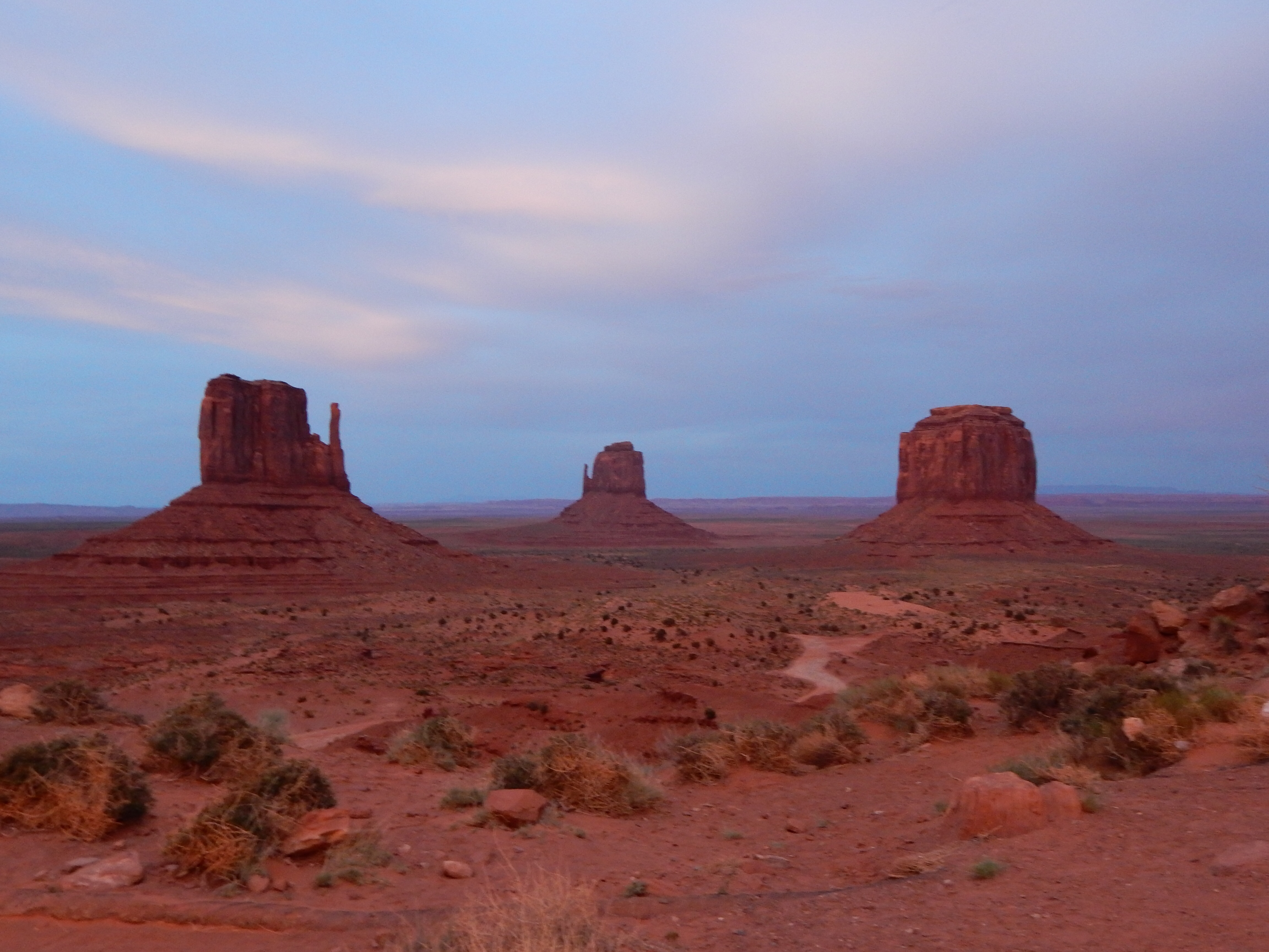
sunrise Monday showing left and right mitten
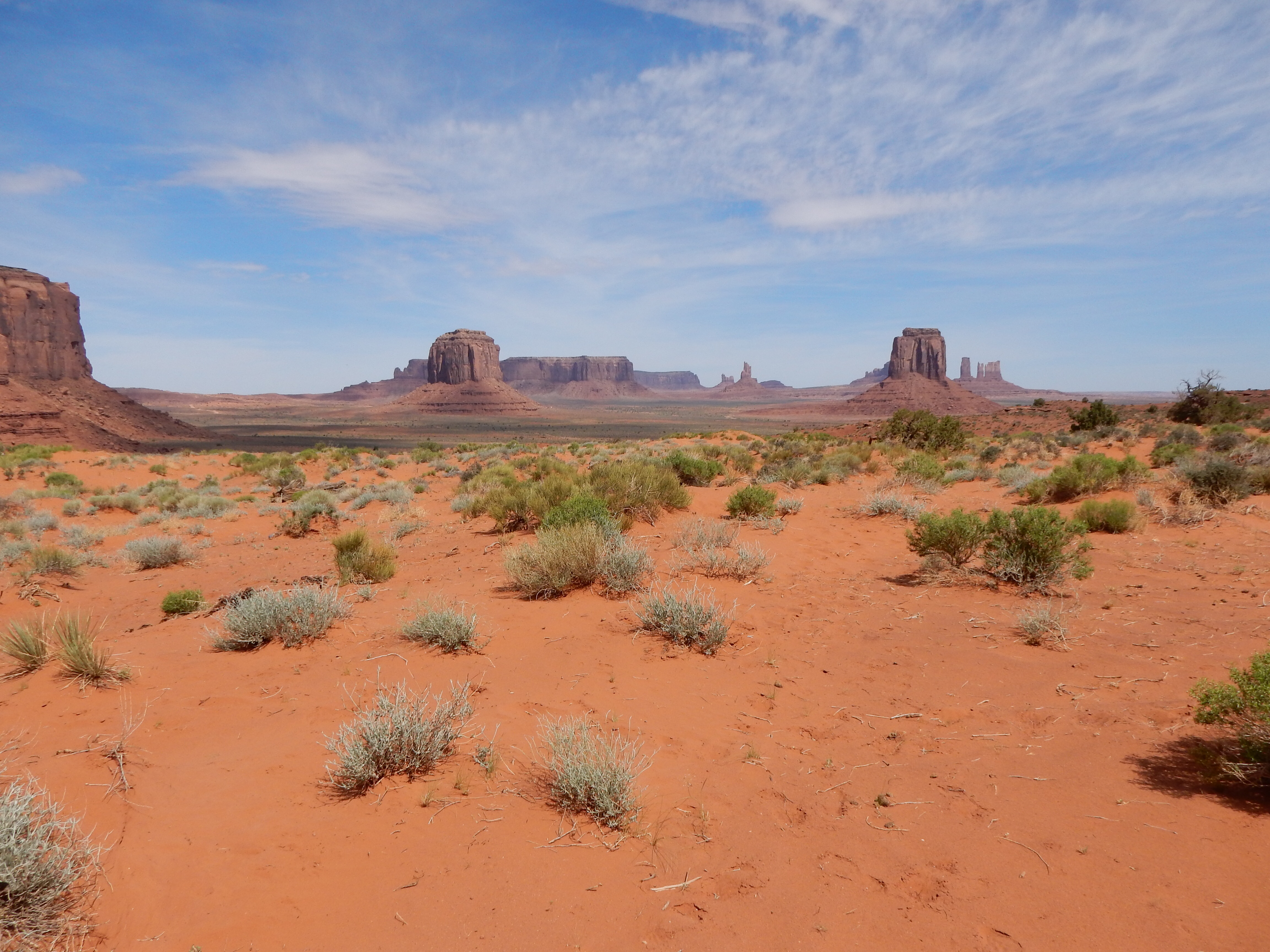
We left Monument Valley Monday morning. We had heard it stated that 80% of the visitors there were from foreign countries. It would not be hard to believe. U.S. National Parks, and Monument Valley is similar to one, seem to have a great attraction for international visitors. Japanese tour bus groups compete with French and German language visitors. Sometimes it makes our interactions with U.S. travelers more memorable.
The drive to Moab
The pharmacist at the Moab drug store was born in Kenyon, MN. We met two couples from Tallahassee FL and discussed with them our recent visit there. A park ranger born in West St. Paul, MN. A couple from Lincoln NE who raved about the quilt museum there that Chris has wanted to see but has not made it into our schedule yet.
Winslow Arch along the drive to Moab
But the Monday drive was less about people and sights than just plain travel. One of us was a little more concerned about the low engine coolant light. The drive from Monument Valley to Moab goes through territory that can safely be described as sparsely settled. After two hours we reached a town large enough to have an auto parts store and I purchased a container of pre-mixed coolant (rather than buying anti-freeze and mixing it with distilled water). Of course, you can not remove the coolant cap when the engine is hot so the actual addition occurred later in Moab but we had the material just in case.
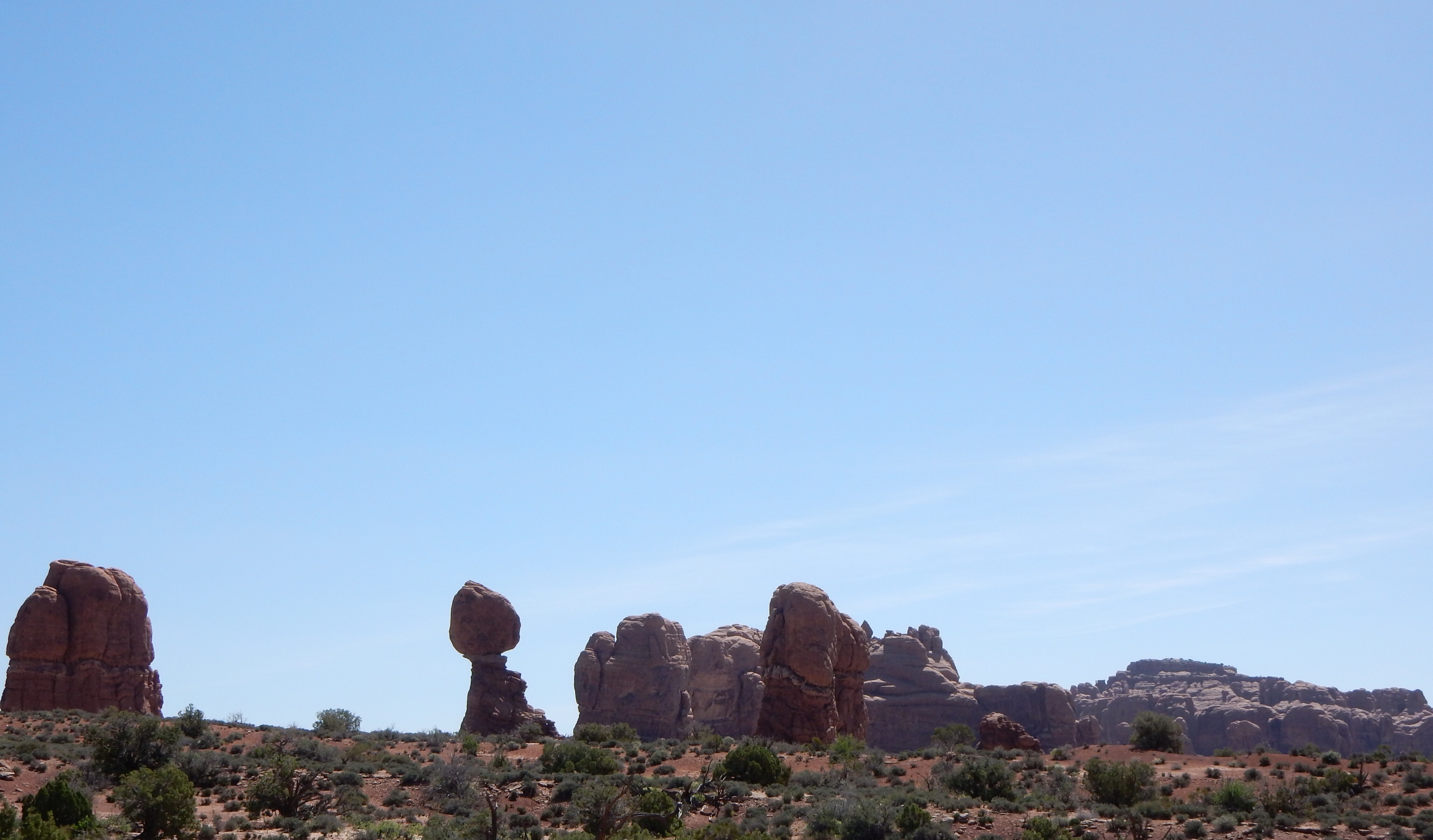
Balancing Rock in Arches NP
This area of Utah is part of the Colorado plateau which encompasses large portions of CO, AZ, UT, and NM. Much of the land is high (altitude) desert with varying degrees of vegetation. We left the red rock and little vegetation of Monument Valley and have encountered mountains, some irrigated land, increasing vegetation, and more red rock.
rock formation with small arch
Moab is at a lower elevation than most of the surrounding area. The Colorado River runs through it. Tourism is the main business now, but mining is still occurring on a limited basis. This town was a big uranium mining locale. The mines have shut down and in classic U.S. fashion, the mining company declared bankruptcy and the U.S. is in the early phases of a 20 year plan to remove uranium mining tailings and ship them by rail to a more isolated site 30 miles north of town.
We are in Moab because Arches National Park is about 5 miles north and Canyonlands National Park is about 30 miles southwest.
landscape along ranger hike
Tuesday was our first day for Arches. The park was crowded but we took in a ranger hike and several hikes to view the park. Arches is smaller and more compact than Canyonlands. It is supposed to have over 2000 arches-which by definition must have an opening at least 3 feet in diameter. Bridges (like Rainbow Bridge) are formed by moving water. Arches are formed by wind, ice, water and upheaval forces working at the varying rock layers.
Landscape Arch
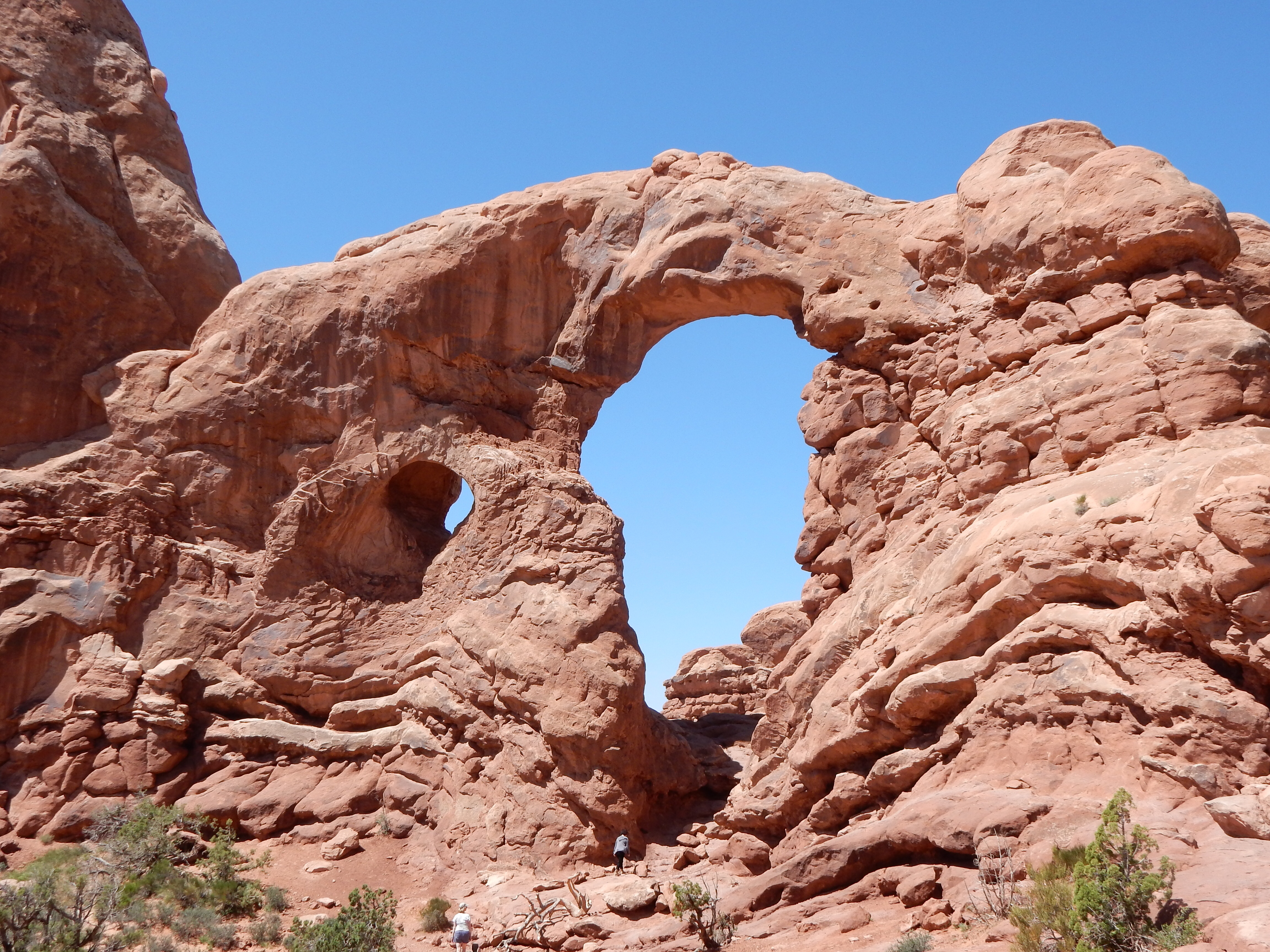
Turret Arch
Landscape Arch, one of the longest in the world, had a large section of its lower arch fall in 1991. No one was hurt. Another arch fell down in 2008, heard but not seen by campers as it occurred. I did not hear or read about any new arches being formed/discovered.
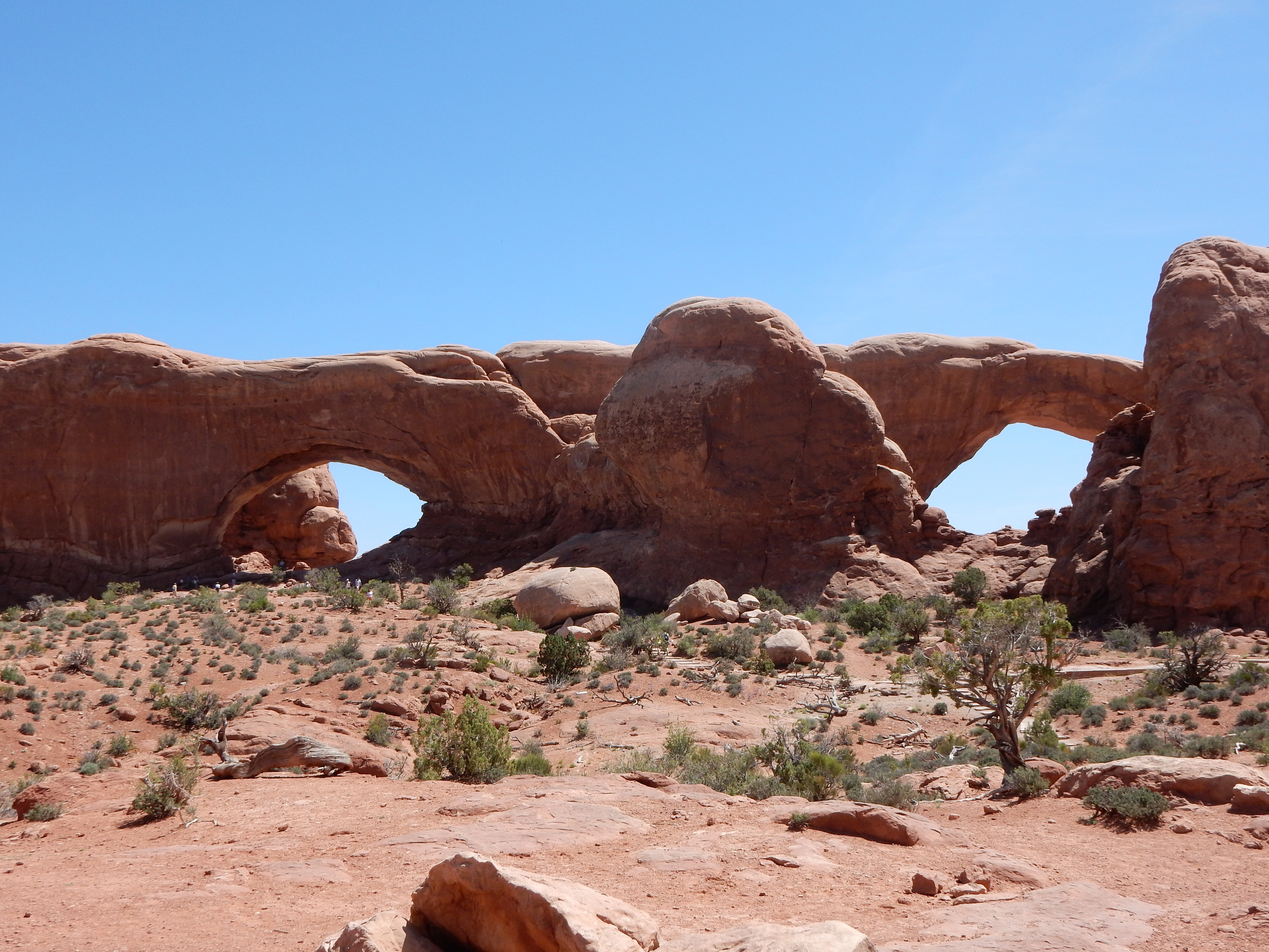
North and South Window arches
Hike to Landscape arch
Dinner Monday was at a local Italian restaurant and Tuesday night we went to a restaurant located in the former house of the geologist and prospector Charlie Steen who first found significant uranium ore in Moab and became a millionaire. The house/restaurant are on a hill overlooking Moab. The food was excellent and features numerous local recipes. We were pleased.
Tuesday May 20 at Moab Utah for Saturday-Sunday May 17-18, Monument Valley, Arizona
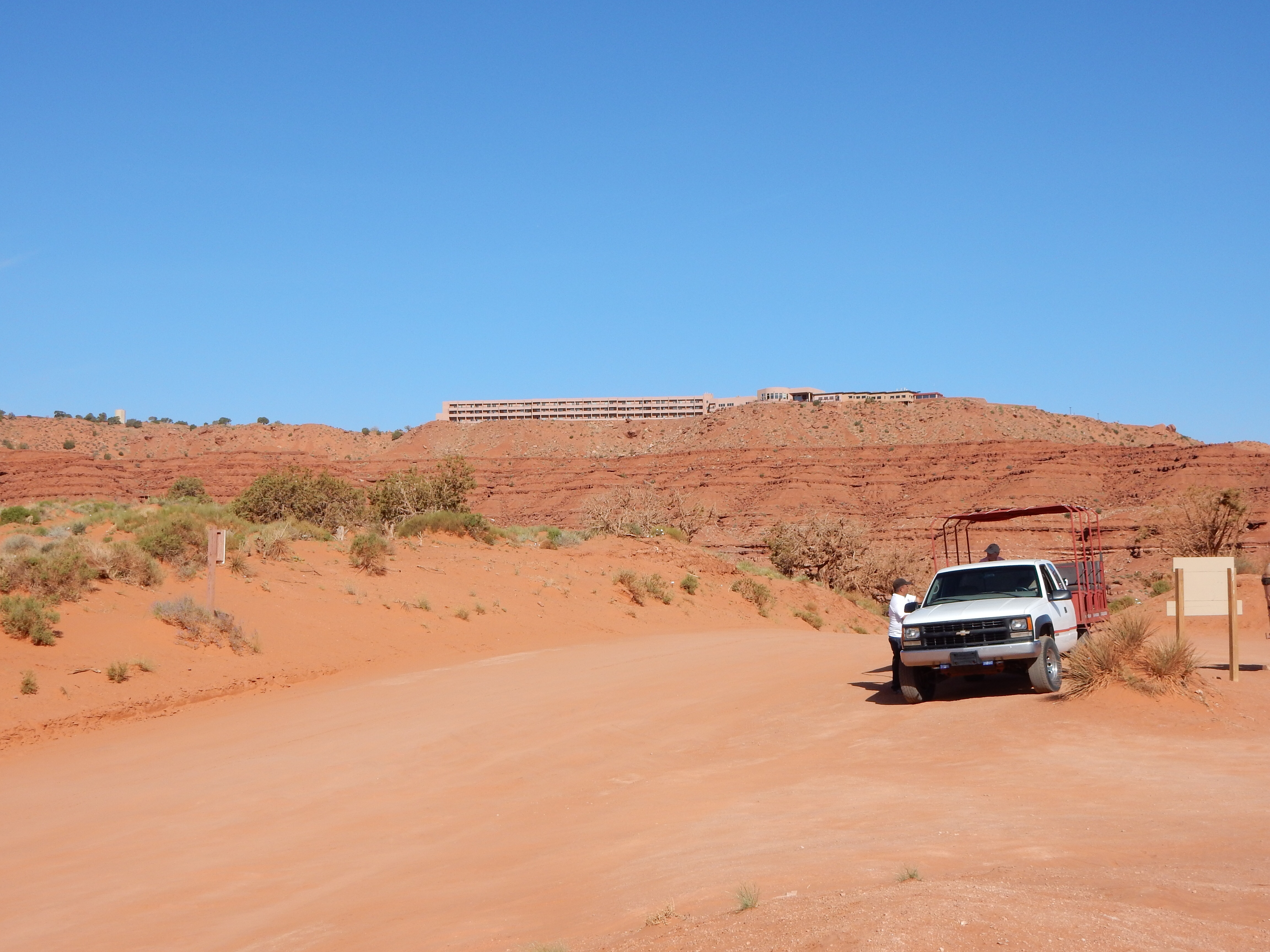
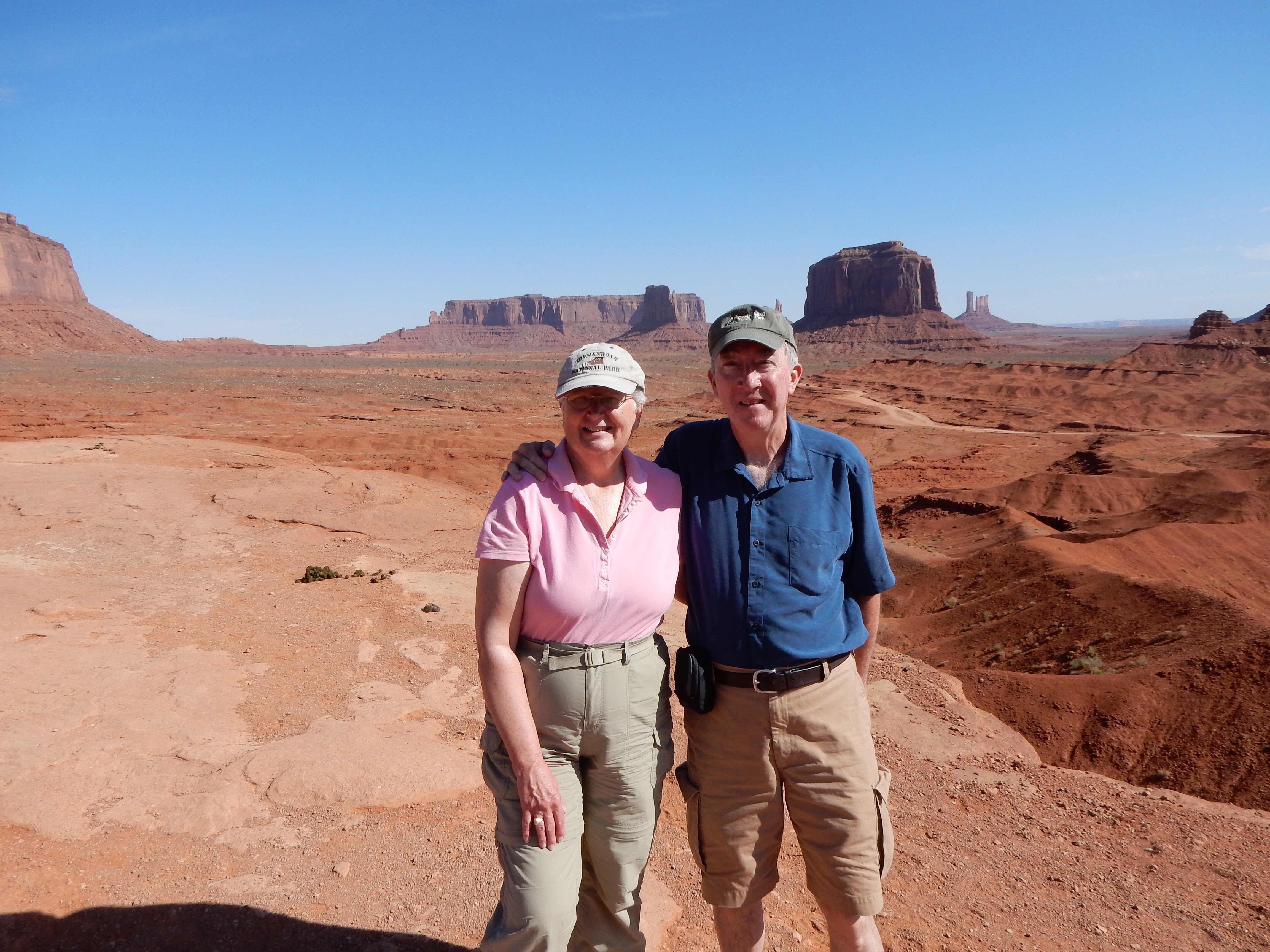
Monument Valley is a Navajo Nation Tribal Park, not a U.S. National Park. We are staying at the View Hotel, owned and operated by the Navajo. It is situated with each hotel room having a direct view of Monument Valley’s stone monuments.
A visitor can access parts of Monument Valley. Other portions are only available to visitors who hire a Navajo tribal guide. We decided to go with a four hour guided tour. All tours are paid in cash. For those of us who are used to formal accounting processes, one wonders about the accountability.
Our tour ride with View hotel in background
The vehicles are usually a modified pick up truck with three rows of raised bench seats with a canvas sunshield in place of the pickup bed. The road that is traversed is dirt and rough. High clearance vehicles are strongly recommended. We observed several private cars embarking on the road, we hoped they made it safely. Our Saturn would certainly not have.
On the valley floor
Dan was our guide. We had one other person on the tour. Larry is a football coach who has made numerous visits to Indian country. We had enjoyable discussions with him over the course of the tour.
The monuments form a W and a V for Welcome Visitors
Like most areas within the Navajo Nation, there are also numerous opportunities to purchase native art, jewelry, leather products, etc. If you visit this area, it seems like every scenic overlook, wayside rest, or even wider spot in the road has several vendors.
sand ripples
Anyway, back to Monument Valley. Over the course of the three hours, we descended to the valley floor so the base of the monuments are at our level and we look up at the tops. The valley floor is also home to many Navajo families who live here, raising crops and horses, living without running water and electricity in order to preserve native ways.
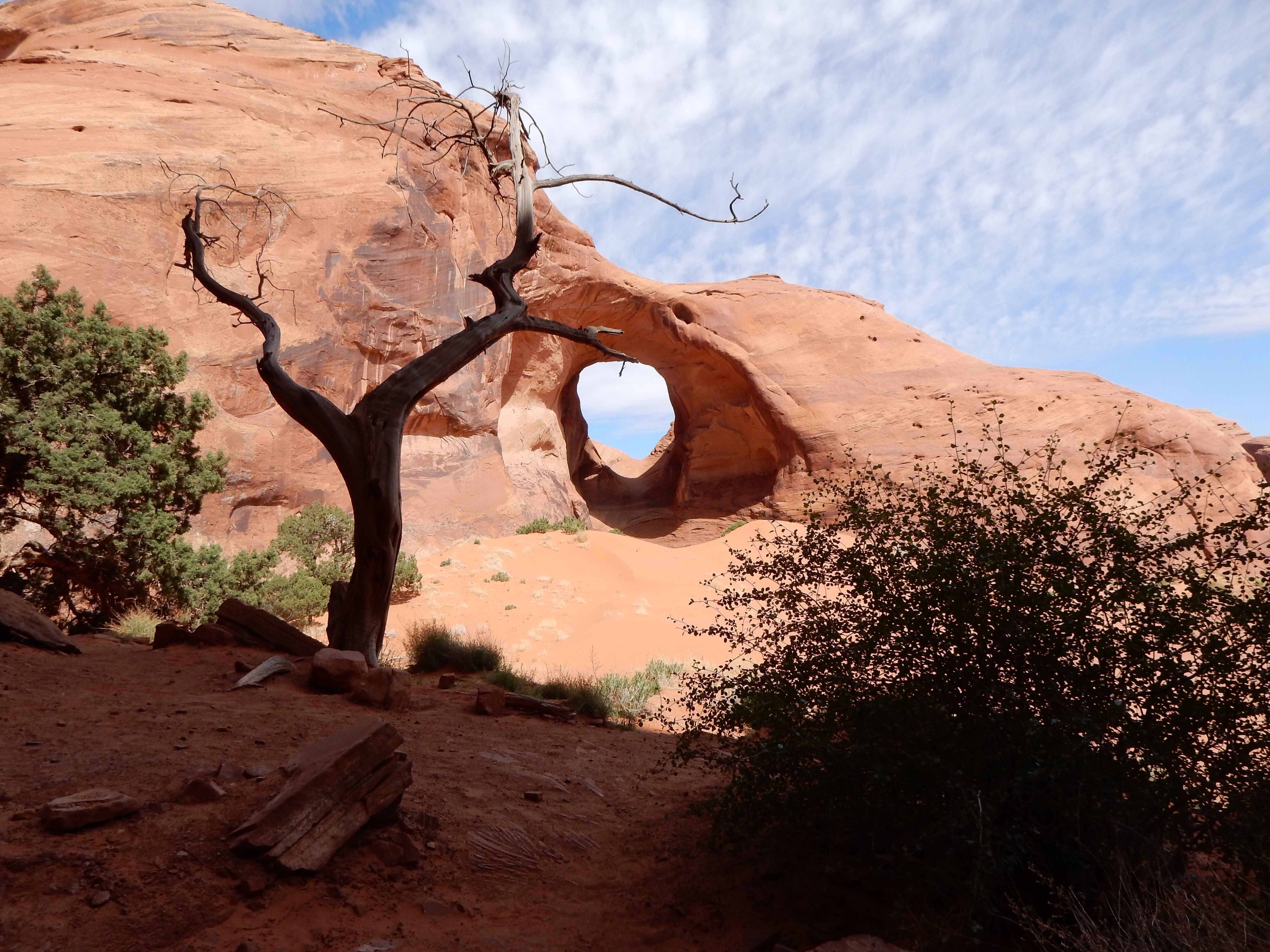
One of the arches
another arch
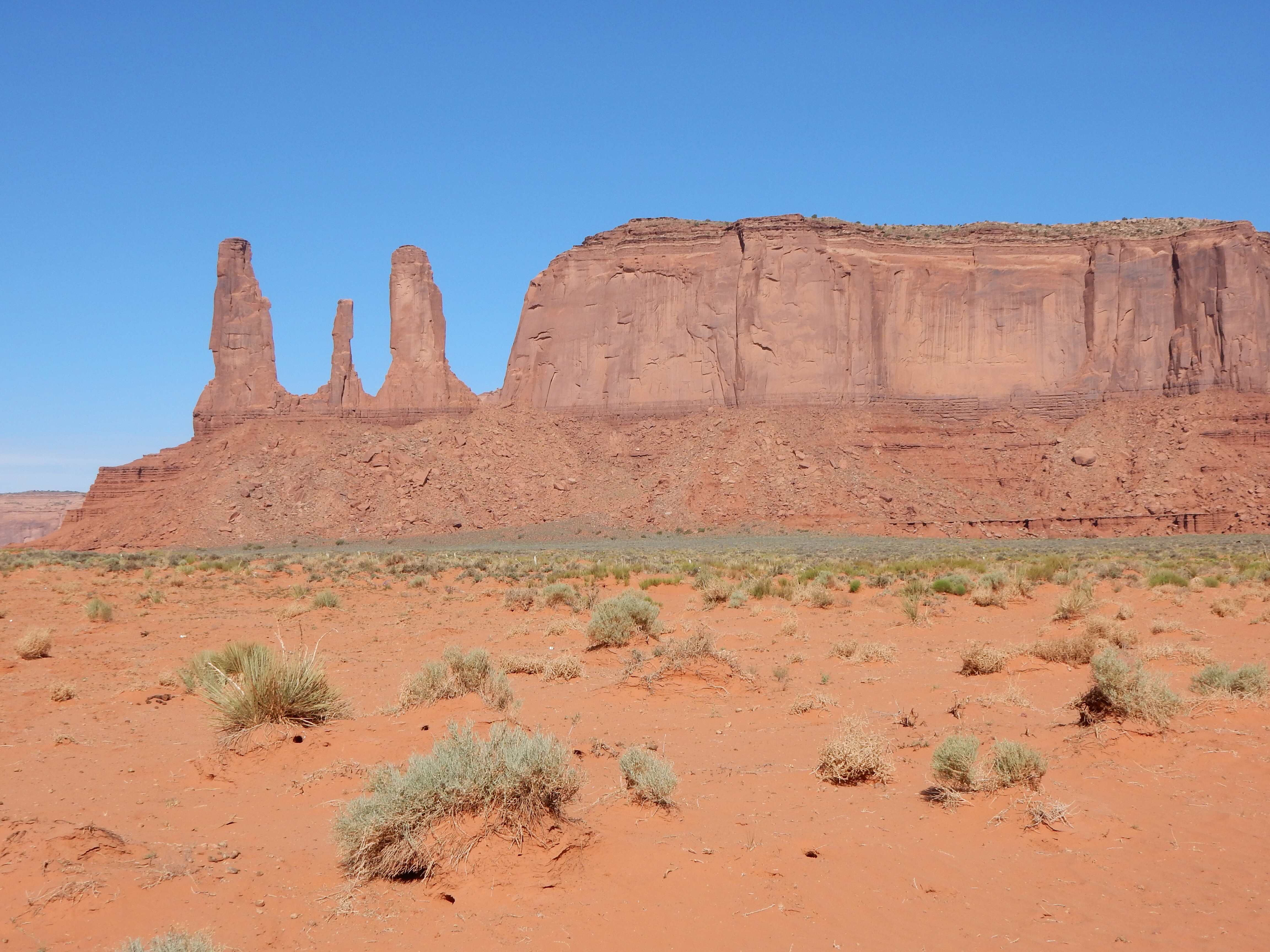
The formations vary from slender rock monuments to massive buttes. Many of them are named for their shape. In my mind, like astronomy, you need a vivid imagination to align the monument with its name. Two exceptions, left and right hand mitten do seem to clearly resemble mittens. We observed several arches along the route.
petroglyphs
general view
In the afternoon, we went through the museum attached to the hotel and restaurant. It had a special exhibit focused on the WWII Navajo Code Talkers-the special group of Navajo assigned to the Marines in the Pacific War who transmitted messages to Marine units in Navajo code that the Japanese could not crack. There was a section that related how uranium mining occurred here during the 1950s to 1970s; how it profited certain corporations but the uranium health impact was very slow to be revealed and medical help not provided. It was not until 1990 that the US accepted responsibility and not until 2008 that clean up activities begun.
Dinner was at a privately owned restaurant/lodge/tour center across the street. Actually, as I reflect better, it is about 6 miles away and across the state line in Utah. There is so much open land here, 6 miles seems across the street. Getting to our hotel meant driving through Arizona from Page, crossing into Utah, and then as we drive up to the hotel and tribal park, we double back into Arizona.
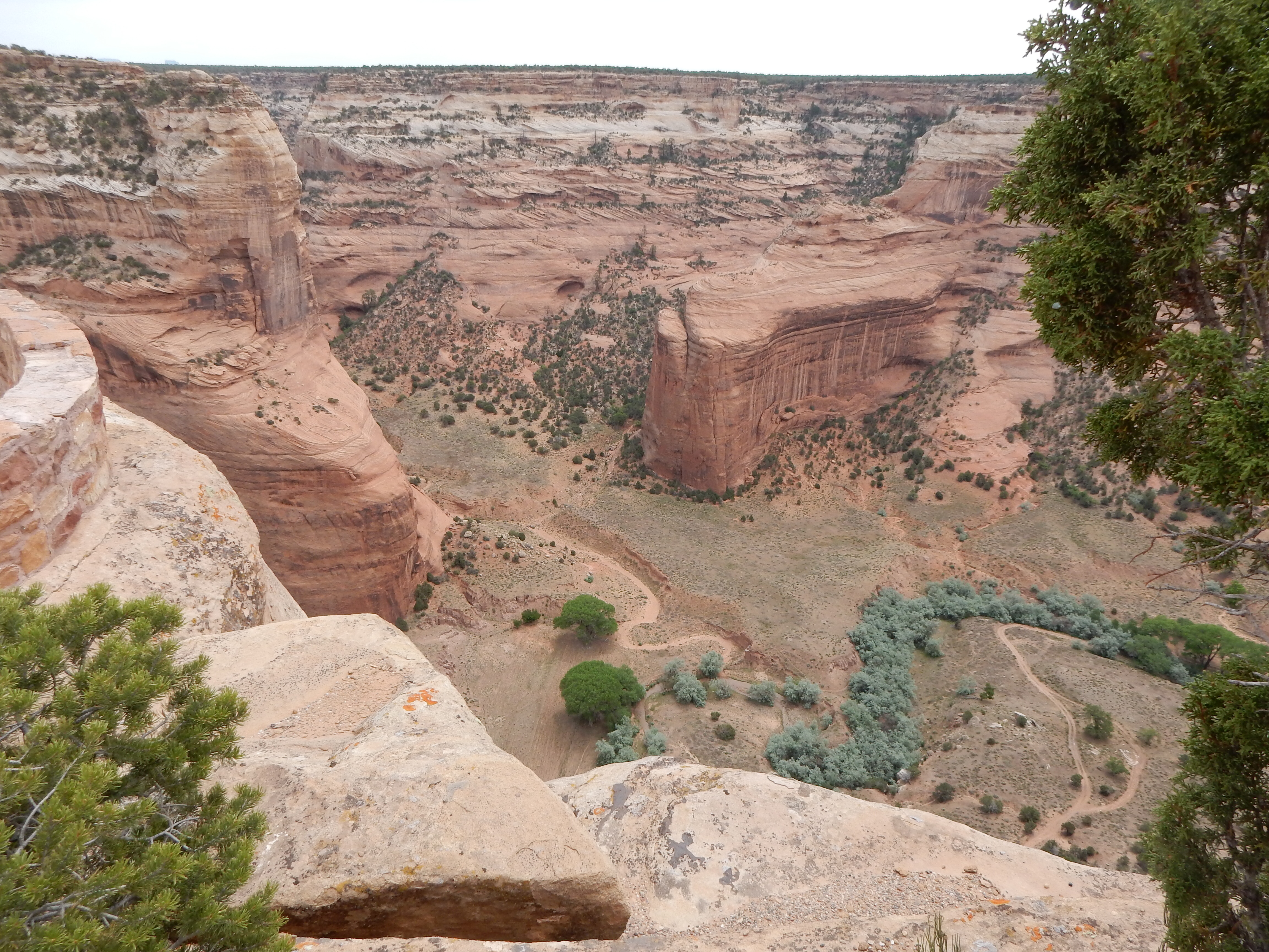
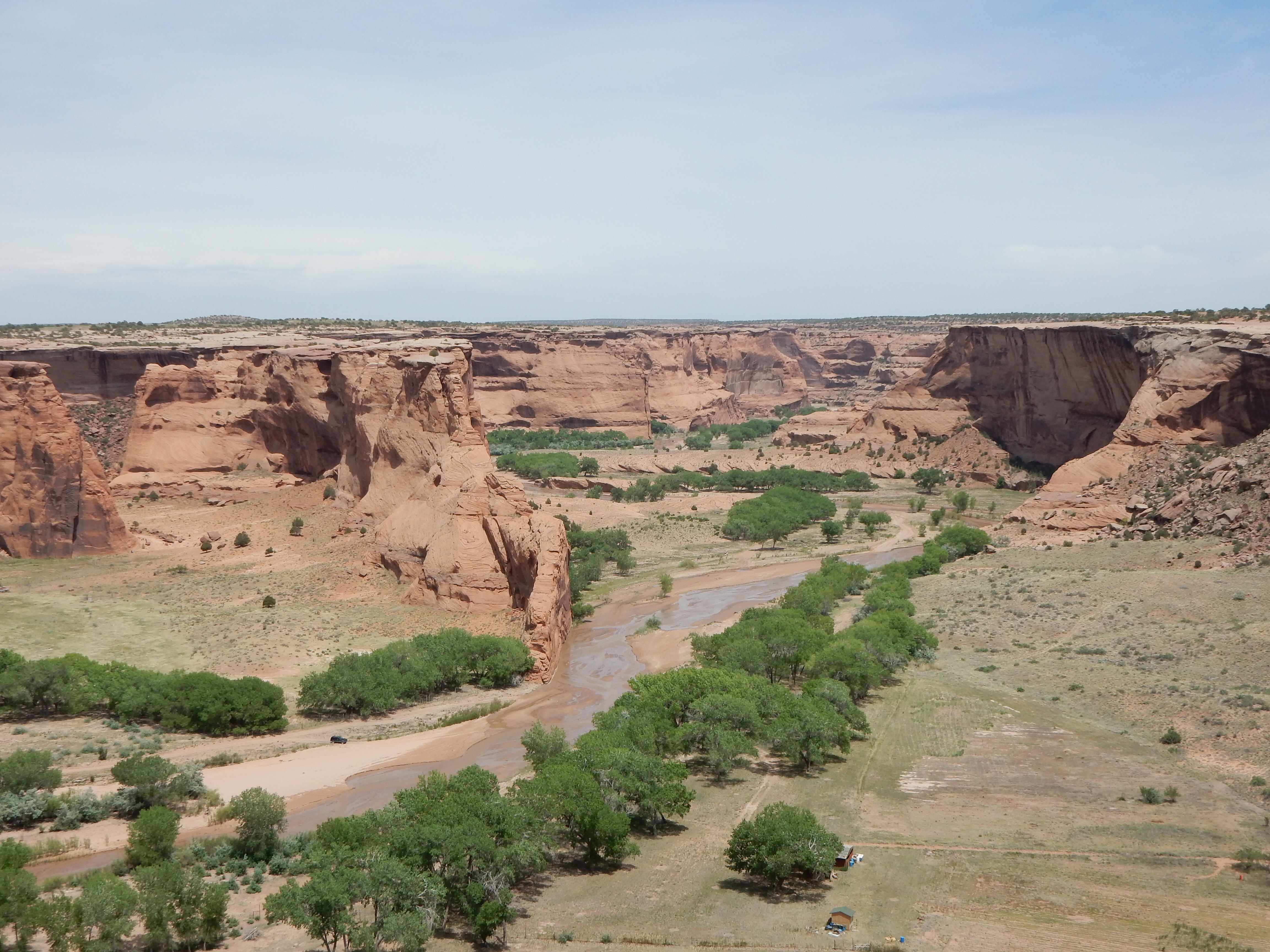
Sunday, Canyon de Chelly (Shay)
Canyon de Chelly
Canyon de Chelly was established as a national monument in 1931, however, it is on land owned entirely by Navajo. It is the only such cooperatively owned/managed park unit. We reached it after a two-hour drive from Monument Valley going southeast into Arizona.
home on valley floor
Canyon de Chelly is reputed to be one of the oldest continually inhabited landscapes in the US, going back to 2500 BCE.. In more recent times, Col. Kit Carson in 1863 and 1864, entered the canyon, killing Navajo, their animals, and destroying homes. Survivors were forced to walk 300 miles to Fort Sumner in New Mexico where they were interred until allowed to return in 1868.
Canyon de Chelly
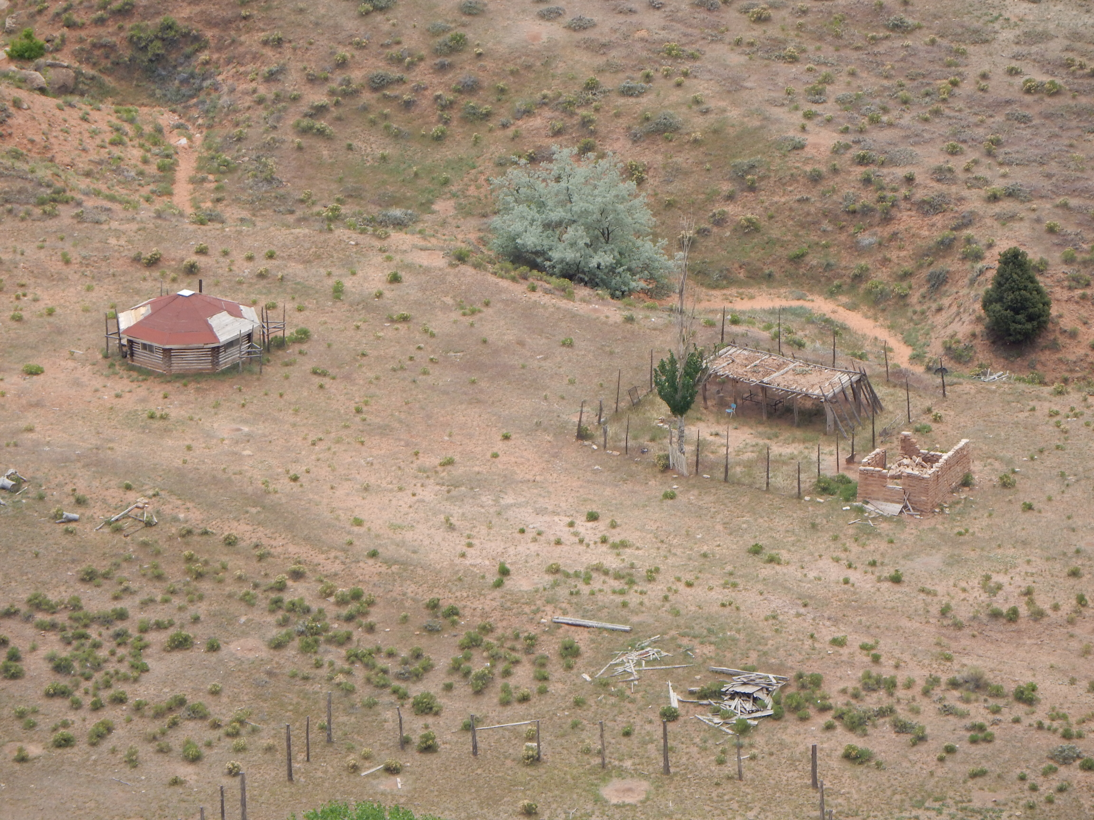
Today, families still live in the valley. Once again, if you wish to visit the floor of the canyon, it must be done with a tribal guide. This time we opted for just viewing the canyons from the North and South rim drives. The canyon walls vary in height from 30 feet at one mouth to 1000 feet. The rim drives are accessed from roads that look no different from many others we have driven on. The canyon appears almost out of thin air once you take the access roads leading from the main highway.
cliff dwellings
another view
The views are almost magical as you look down into this immense canyon with green next to the creek on the canyon floor. Homes and people can be spotted periodically. No way down from the rim to the floor was obvious to us.
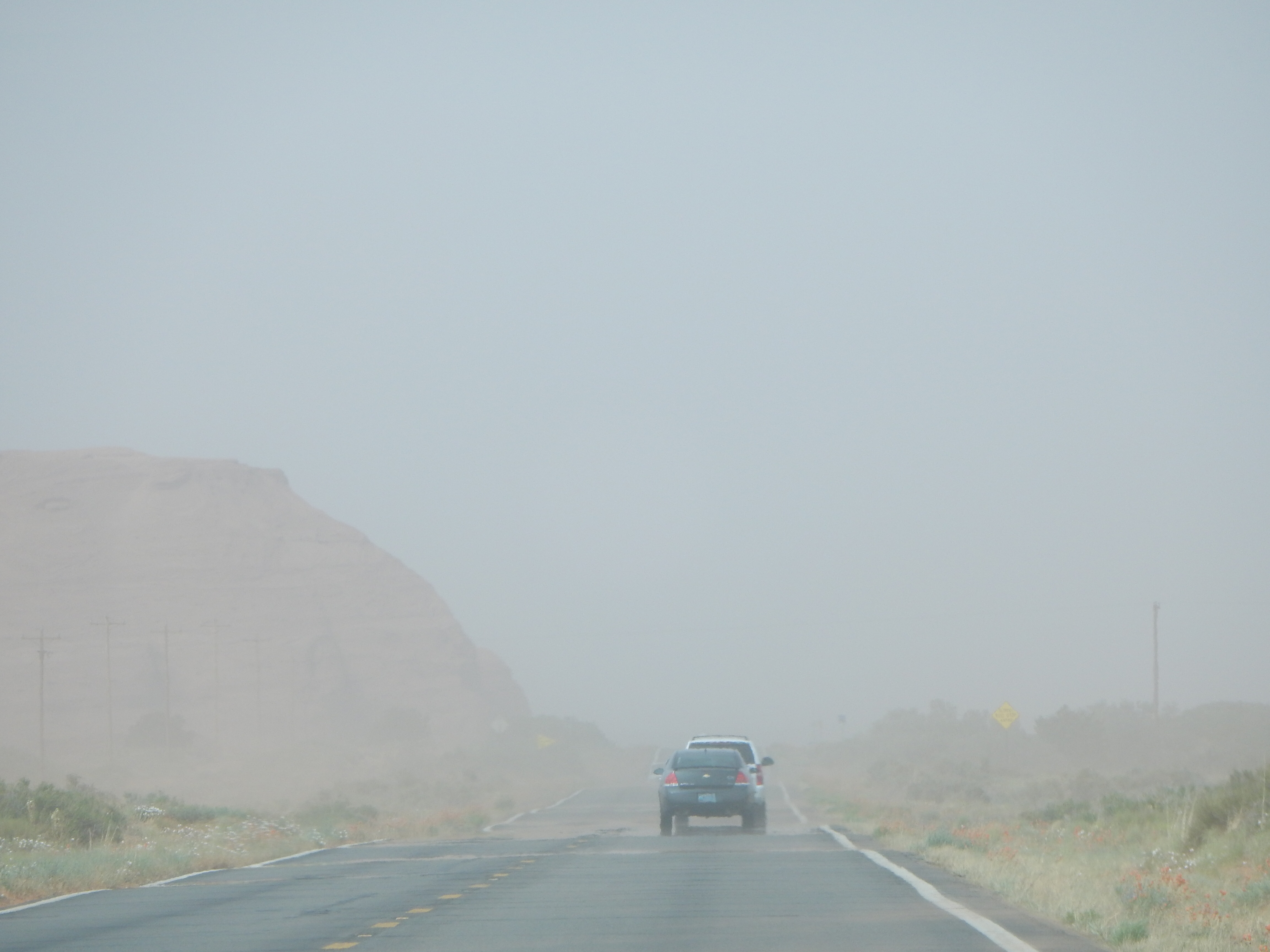
dust storm
Our drive back to The View Hotel in Monument Valley had two new twists. One, we came upon one of those wind-driven sand storms that makes driving a challenge. Two, the warning light for low engine coolant came on. The car was not overheating so we decided to resolve that issue Monday.
at the end I have attached a brief video from Monument Valley. I hope it replays satisfactorily
Tuesday May 20 Moab Utah for Thursday and Friday May 15-16, Lake Powell and Page AZ
The Great Adventure came to an end. We agreed it was more of an adventure than a vacation. The vistas were great, the hikes enjoyable, Rainbow Bridge a delight, the narrow canyons by powerboat a thrilling adventure, and the food and camaderie could not be beat. But, the nervousness over uncertain tasks to be accomplished, the suspense over the anchoring, and the unexpected hard work removed it from the vacation category. We certainly stretched our personal boundaries, successfully.
Dawn broke early with clear skies foretelling a great day ahead. Smooth sailing was forecast. The early morning was spent cleaning up, packing, and getting ready to unmoor. The powerboat had to be removed from the back of the houseboat and beached before we could take off. The four anchors had to be undug and stowed on the boat. Manning had to be taken for his last walk.
Joyce at the helm
Once the powerboat was beached, Lou pushed up the gangplank on the houseboat and Joyce revved up the houseboat motors and shoved it in to reverse. We were unbeached. Lou had the chore of pushing the powerboat off the beach, hopping on board and then maneuvering it into position behind the houseboat where it was once again tethered and towed behind us. We were heading back to Wahweap Marina.
We left about 10:30 and arrived at 1:30. Maneuvering through the channels was a bit easier for Joyce; she even gave Lou a lesson on driving the houseboat. Wislely we called again for a pilot to come out and bring the boat in for re-fueling and then anchoring at the dock.
Maning with his life jacket
Our last looks were from an overlook of Lake Powell and the Glen Canyon dam. The dam was constructed over ten years, 1956 to 1966. 17 workers died during construction. The purpose of the dam is to impound water to control downstream flooding, water storage for the southwest and hydroelectric power. It took another 17 years for the water to rise to full levels. At full level, the lake depth is 560 feet at the dam.
Lake Powell is the second largest man-made lake in the U.S. It is 186 miles long with 1,960 miles of shoreline. There are 96 major canyons to explore. The Glen Canyon National Recreation Area encompasses 1.25 million acres, the lake is only 13% of the total.
We had to be off the boat by 3:30 and waiitng for the pilot and re-fueling took a while. We had gotten lazy and enjoyed the ride back so we still had to pack up the food, etc. But we made the deadline and then it was off. Joyce and Lou to the Lake Powell Resort where we spent Thursday night. Ed and Chris first to a drugstore to get medications for a cold and sore throat Ed picked up Wednesday. After four long hot showers we had an excellent dinner with alcohol at the resort restaurant.
Dinner
Friday morning was departure day. Ed and Chris made a stop at Urgent Care (got there when they opened) to determine if Ed had strep throat. Ed did not. Then we did laundry and had breakfast.
Given Ed’s cold and sore throat, and Joyce’s not feeling well, we decided to pass up the jeep tour of the Antelope Canyon. This is supposedly one of the most photographed slot canyons in the US. We will have to make it another time.
Our next several days will be a bit more relaxed due to Ed’s cold and sore throat so if the narrative is skimpier than usual you will understand.
Horseshoe Bend
We did spend a while hiking to Horseshoe Bend, a spot south of Page where the Colorado River makes, what else, a horseshoe bend. Our photo is not perfect. I was not willing to lean over the edge to get a spectacular photo.
Our next three nights will be at Monument Valley, a Navajo Nation Tribal Park. The drive was only a few hours and the hotel is noted for its views of the valley. Monument Valley is named for the numerous stone outcroppings located here. You will see many pictures in the days ahead.
Monument Valley AZ, Sunday May 18 for Wednesday, May 14 on Lake Powell
Lake Powell
Wednesday we needed Joyce at her peak skills and she came through admirably despite still being under the weather. We were to drive the powerboat 35 miles and visit Rainbow Bridge National Monument. The final mile was down narrow canyons and then we would have to walk to the site.
Heading up to Rainbow Bridge
Once again we navigated the main channel of Lake Powell. Lou and Chris did an excellent job of spotting the channel markers. One moment was memorable. We hit one wake and the boat bounced up in the air. So did Manning, we watched him rise a foot in the air and land again on all four paws as it nothing happened.
Forbidden Canyon
Joyce piloted us to Forbidden Canyon, and then down Forbidden Canyon to the floating dock the National Park Service maintains for visitors like us. Only, the NPS does not allow pets on the floating dock or at the monument. Ed and Chris took the first hike while Lou and Joyce stayed with Manning and ate their peanut butter and jelly sandwiches.
Forbidden Canyon
The ride in and out of Forbidden Canyon was breath taking and nerve wracking. The canyon walls are tall and the stream is narrow. It took all of Joyce’s skill to avoid hitting the walls or getting grounded. Too bad we did not have any champagne to toast her when we got back.
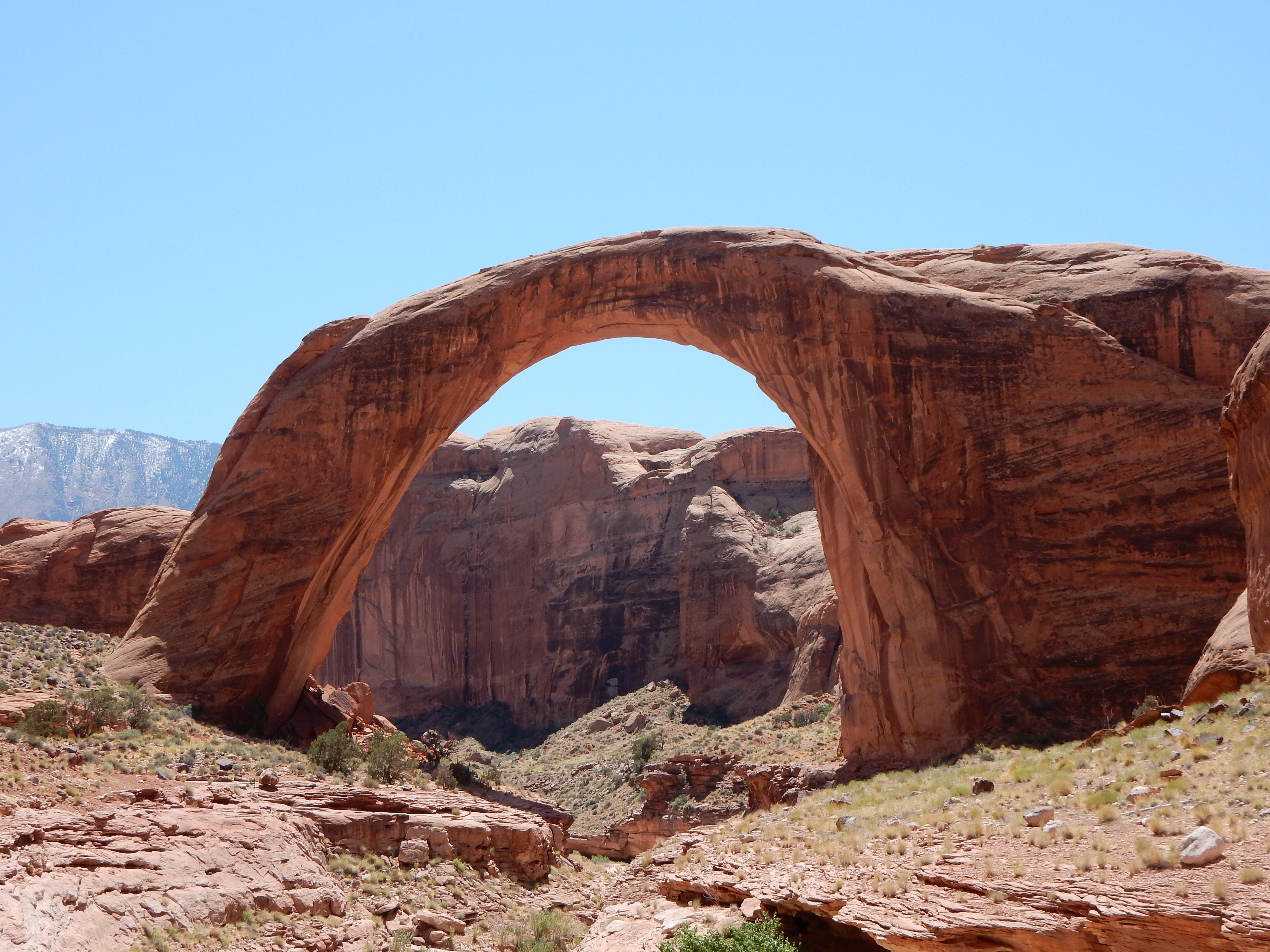
Rainbow Bridge National Monument
Rainbow Bridge was not publicized until 1909 when two exploring parties joined forces and “found” it. In 1910 President Taft created the Rainbow Bridge National Monument. The bridge is 290 feet tall and the span is 275 feet across the river. The top of the arch is 42 feet thick and 33 feet wide. It was a remarkable site to behold.
Driving the narrow canyons
After Lou and Joyce made their trip up, we retraced our steps, somewhat, to the houseboat. We made a secondary stop at Dangling Rope marina to top off the gas tank and get some ice cream. The way there was a challenge as we went down some narrow canyons again. We certainly got our fill of challenging power boat driving.
Wednesday night camp fire
Back at the houseboat, we got ready for our final dinner and then a campfire on the beach. We had found several fire rings on the beach and selected a close one, upgraded it, and made S’mores watching the moon rise and fire burn. A great way to end the day.
Sunday May 18 in Monument Valley AZ for Tuesday,May 13 on Lake Powell
Lou and Chris looking out at Gunsight Bay
Tuesday was a hiking day. In the morning, Lou, Chris and Ed returned to the canyon stream bed they discovered Monday and hiked it further to the point of no advancement-unless you were in to rappelling which we were not. Along the way we came across several places with a profusion of wildflowers. At a bend in the creek bed, Lou and Chris discovered several schools of tadpoles. We followed the stream bed out to the lake and then went up the cliff.
A view along the morning hike
Climbing the cliff was a challenge but we handled it. This was an intermediate cliff, not the several hundred foot cliffs behind the houseboat. The views were grand and we felt proud of ourselves for accomplishing the climb up-and back down.
Lou jumping the creek
After lunch, since Joyce was still feeling poorly, Chris and Ed went hiking in the opposite direction along the base of the cliff. Chris resisted the urge to stop in at the other three houseboats parked a ways down the beach.
Area of the afternoon hike
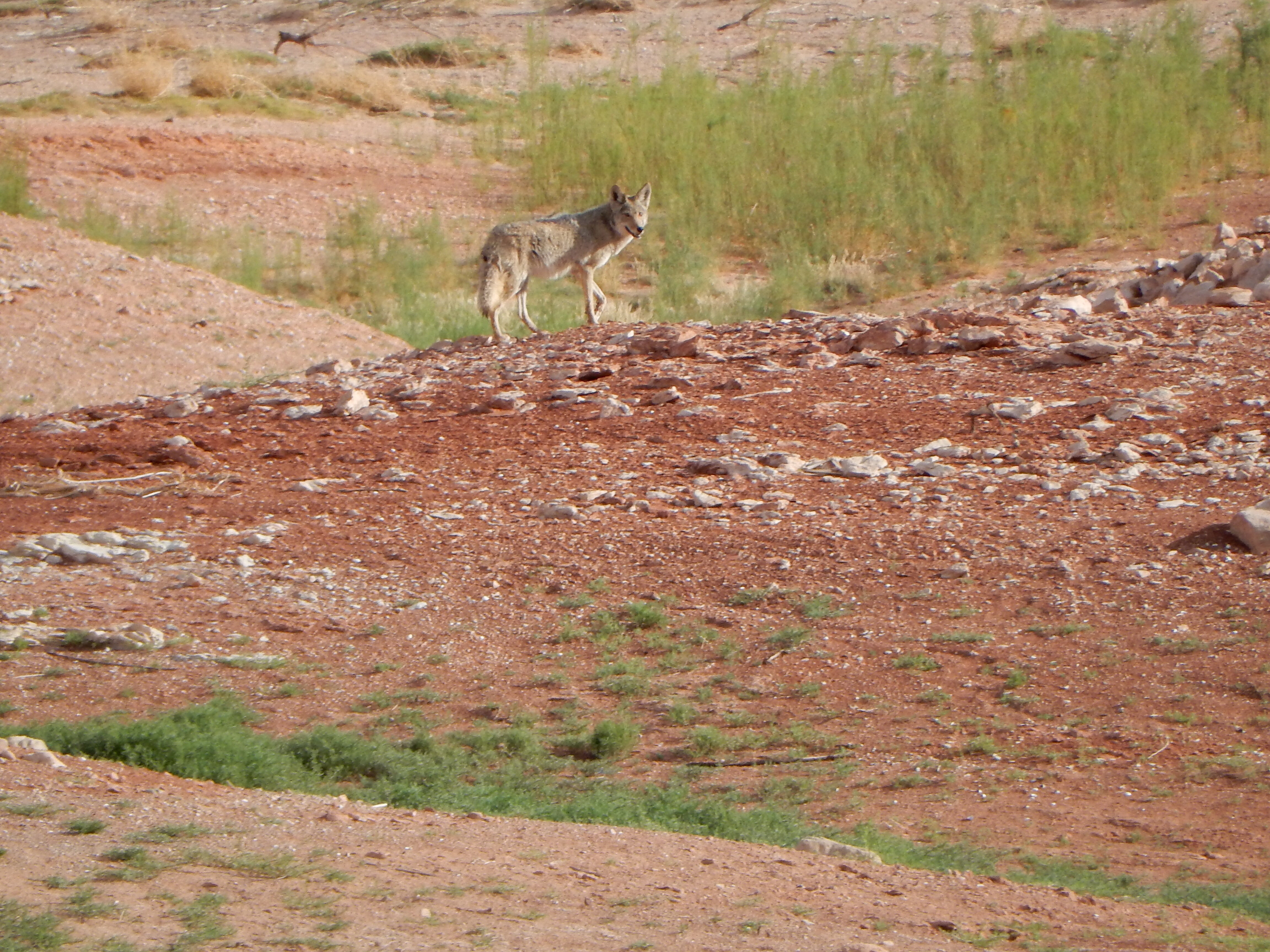
The hike was flatter than the morning hike and I can not say that we discovered anything unusual, but the open air and grand vistas were rewarding. When we returned from the hike, as we were sitting on the deck of the houseboat, we saw a coyote prancing along the area where Manning usually takes his walks. After that, Manning was always on a leash.
Our coyote visitor
Dinner consisted of grilled pork tenderloin, baked potatoes and fresh green beans. The moon rose over the lake again providing dramatic views. Even better, the wind was calm and the water was smooth so the boat was pretty much stationary during the night.


Recent Comments